Return to GeoComputation 99 Index
Jochen Schmidt,
Holger Gärtner, and
Richard Dikau
Department of Geography
, University of
Bonn, Meckenheimer Allee 166,
D-53115 Bonn Germany
E-Mail: jochen.schmidt@uni-bonn.de
It is an open research question to which extend landslide activity contributes to landform evolution, especially under moderate humid climatic conditions. In a multidisciplinary research project at the University of Bonn, we are trying to get insight into the process of slope development through mass movements. Research methods include local field investigation and stability analysis, mapping and modelling of landslide susceptibility, geophysical subsurface monitoring, and geomorphometric slope profile analysis. Research aim of the coupled use of these different techniques is to model quantitative measures for sediment transport through landslides on hillslopes in the Bonn area. In this paper, the research approach, methods and a few first results are presented. Special emphasis is given to the data management: The scheme and system used to store and manage the data and analysis results is critically discussed. Additionally an alternative, object-oriented approach is presented.
In quantifying the sediment transport through mass movements over
longer time scales, we have to cope with several problems, e.g. (1)
unknown boundary conditions in time, (2) discontinuity of the process,
(3) different process types, (4) coupling with other (slope)
processes. Therefore, a statistical approach, coupled with slope
stability analysis is used to estimate the contribution of landslides
to slope evolution under variable (i) climatic, (ii) morphometric and
(iii) geologic boundary conditions. First, several indices describing
mass movements over longer time scales were itentified and selected
for the study. Slope profile types are extracted for the study area
using several morphometric algorithms. Material properties from
laboratory tests are related to geologic units. Several slope
stability models based on different approaches are used to model the
selected landslide indices under different morphometric and geologic
conditions. The models are calibrated using data from several
landslides in the Bonn
area (see below). First results show the
dependency of landslide occurence in the Bonn
area on hillslope
morphometry and geology. These findings are used in an sensitivity
study on the influence of different climatic conditions, which shall
lead to an estimation of spatio-temporal landslide activity.
Investigations on sites near Bonn
(Germany) are carried out, producing
a large amount of field and laboratory data. Supplementary information
is available by climate data, geologic maps, topographic maps, DEMs,
etc. Additionally, data resulting from interpretation, analysis and
modelling of the field data must be handled. In our project, storage,
visualization and analysis of these data is realized using GIS
(Arc/Info
, GRASS
), geotechnical software (GeoDin
), databases (Access,
ORACLE
), slope stability programs and several other software
products. This shows that landslide investigation is a typical example
for the heterogeneity of data and methods used in Geosciences, which
necessitates a careful and consistent data management.
Presently, a relational data model and diverse structures, methods and
tools to handle and analyze the data are used. This (common) practice
complicates the exchange of data, methods and research results. In
contrast, an object-oriented approach, developed in cooperation with a
project on Open Information Systems is compared with classical
concepts. The results show, that object-oriented data modelling can
facilitate user access to multiple datasets, support integrated use of
different analysis technologies and could aid in the development of
standards for exchanging data in multidisciplinary environment.
It is an open research question to which extend landslide activity
contributes to landform evolution. Recent investigations towards the
problem range from local field investigations, local stability
modelling over detailed physical process modelling, simplified physical
process modelling and statistical modelling to conceptual, genetic
approaches (see Hergarten & Neugebauer, 1999b). The problem of filling the gap between actual
process description and longterm geomorphic evolution
is obvious like in no other
research field (Dikau, 1999), because ``on the geological time span over which slope
profile evolve, landslides and other rapid mass movements occur almost
instantaneously'' (Kirkby, 1987). This means, the
change in time scale requires a change in model description. The
discontinouity in mass transport and the formative activity of landslides
cannot be transfered in time by methods of simple averaging and
bilancing, often used in processes with more continuous character.
Therefore, temporal descriptors like lifetime of landforms, reoccurence
interval of events, etc. should be used in discontinuous processes like
landsliding (see Brunsden & Thornes, 1979; Cendrero & Dramis, 1996).
These descriptors can lead to the determination of frequency and
magnitude of landslide activity in space and time
(Brunsden & Thornes, 1979; Crozier, 1996a). Predicting frequency and
magnitude in landslide processes using actual process descriptions as
used in recent stability and movement models is an
important issue in landslide research.
Estimating temporal descriptors and magnitude / frequency behaviours by triggering
thresholds is one possiblity in approaching this problem. The
concept of thresholds was often used in modelling landform evolution,
because of it´s attractive simplicity
(Francis, 1987). The variablity of
thresholds in space and especially time (which means under varying
boundary conditions) is one crucial problem. These varaibility appear to be
related to internal dispositive factors (Crozier, 1996a). However, the utilitity of the concept of
variable thresholds in modelling landform evolution using slope
stability models was shown in several studies (e.g. Brooks et al., 1999; Casale et al., 1993; van Beek & van Asch, 1999).
A related problem, stressed by Palmquist & Bible (1980), is the
identification and differentation of external and internal dispositive
factors as landslide causes and triggering factors leading to slope
failure. They propose to identify important dispositve factors to group landslide
occurrence with special statistical characteristics in space and time.
Recently,
the workshop ``Process Modelling and Landform Evolution'', held by the
Collaborative Research Center (SFB)
350
in Bonn
, addressed the problem of unsolved discrepancy between (1) measurement and
modelling of actual geomorphic processes and (2) description and modelling
of geomorphic landform evolution
(Hergarten & Neugebauer, 1999b), which applies especially to
landslide processes (see above). The actual modelling approaches use well
known field sites and more or less sophisticated models. The evolution models
often use simplified field data (e.g. ideal slope profiles or artificial landform topography) and
comparatively simple
/ statistical / conceptual approaches
(Cendrero & Dramis, 1996; Hergarten & Neugebauer, 1999a; Kirkby, 1987).
Appropriate field data for validation of landform evolution models are
undefined and/or missing (Dikau, 1999). Therefore, validation
of those models often have to be done by methods like the principle of
actualim or the ergodic principle
(Brooks et al., 1999; Dikau, 1999; van Beek & van Asch, 1999).
As part of the Collaborative Research Center (SFB)
350
, we are trying to give a contribution in filling the gap between
modelling processes and modelling landform evolution in a multidisciplinary research initiative. Our approach is
based on combining detailled field investigation,
local and regional stability analysis and models of slope evolution, leading to an estimation for contribution of mass movements to
slope development (see section 2).
In general, two types of landslide investigation can be distinguished:
Local site investigation and regional landslide hazard analysis. In
both cases, the quality of the analysis results depends stronlgy on
the used input data: In the first case, usually more or less intensive
field and laboratory measurement programmes and field monitoring is carried
out, the regional approaches usually gather spatial data available for
the considered area (as geological maps, DEM´s, etc.). However, in both
cases, it is necessary to get as good as possible insight in the
morphometry, geology and ground water situation of the site (Dikau et al., 1996).
Usually, landslide
investigations start with geomorphic and/or geotechnical mapping of the
field site, followed by a drilling programme and analysis of the
collected samples in the laboratory. The produced maps and digital
elevation models can be stored within a GIS environment. Graphical
representation of the drilling and sampling results are often carried
out by specialized software based on national and international
(geotechnical) standards (ISO, DIN, EU) (compare section 4). Various stability and/or hazard
models are
used to analyze the (interpreted) field and laboratory results with respect
to local or regional stability of slopes.
Landslide investigation therefore is
a typical example of a complex geomorphic / geotechnic
investigation. It inheritates the need for multiple types of data and
geocomputational modelling and analysis techniques (see section
3). Finding methods, integrating different datasets and techniques is an important issue. This may not
only assist geoscientists in concentrating more on their work, but can also
help in (interdisciplinary) exchanging of data. New information
systems allowing integrated access to various types of data and
therefore new kinds of queries, could not only simplify our work, but
also extend available information sources.
Additionally, data storage within these types of database management systems
facilitate the analysis process and connect data in a
consistent and recoverable (well documented) way (see section
4). The project OPALIS
is an research initiative of
geoscientists and computer scientists at the
University of
Bonn, working on the development of a framework for
multidisciplinary data integration and data management.
Our research aim is to get insight in the process of slope development through landslide processes for the Bonn area. As indicated in the previous section, this research topic contains several problems:
Therefore the following statements can be drawn:
Modelling slope evolution in time can therefore not be done by
investigating one specific slope, it is also related to a spatial
problem. Stability models are often poor in terms of modelling a single
landslide (also because of poor parameter knowledge). However, if
these models use a general valid description of the physical
relationships and processes, they should
be good enough to model a typical slope system in a statistical
sense. ´Modelling in a statistical sense´ thereby means to simulate
measures of landslide processes within a slope system relevant for
slope development (see table 1 and compare Cendrero & Dramis (1996), Crozier (1973), Crozier (1996b), Crozier (1996a) and Dikau et al. (1996)).
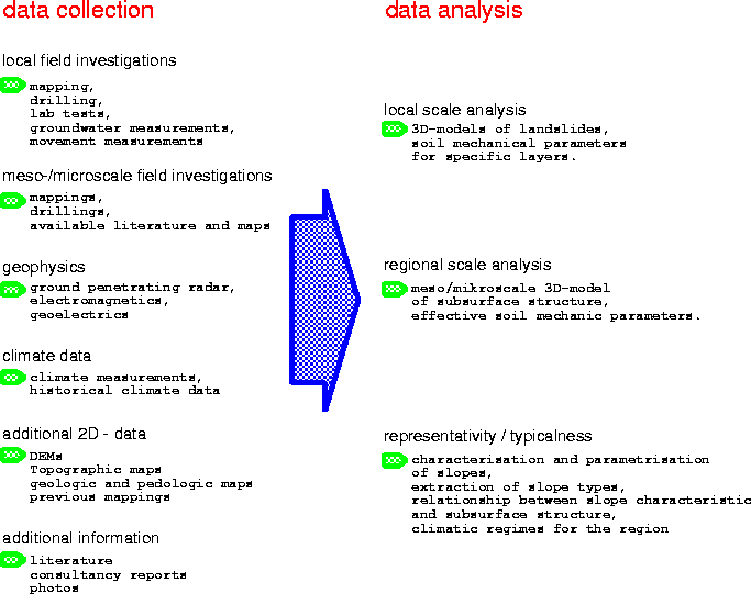
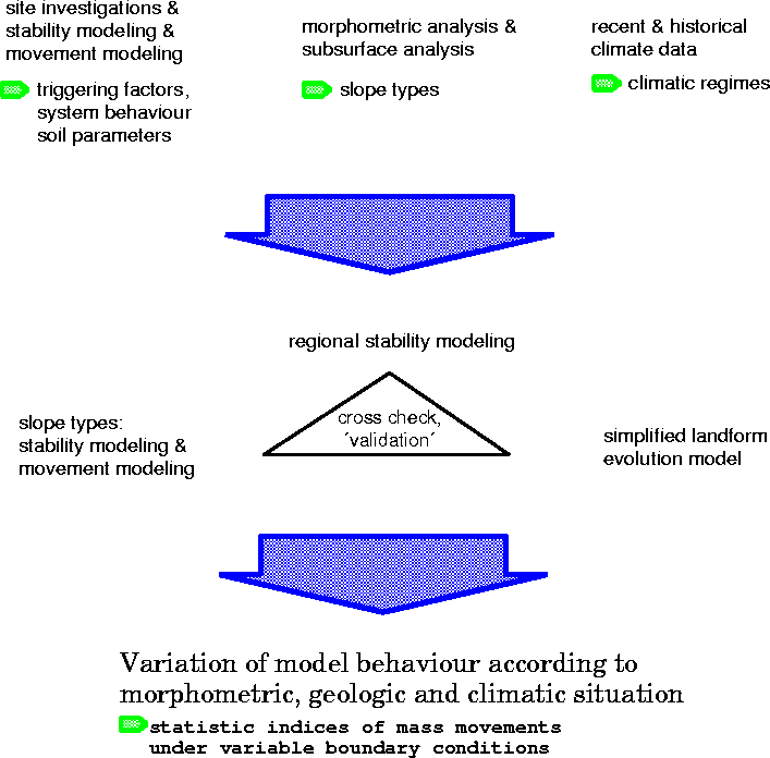
So we can redefine the introductory sentence of this section: We looking for a quantification of mass transport of landslides by modelling landslide measures for longer periods of time, using physically based models for typical (spatial and temporal) situations of the research area. Based on the these statements a research strategy was developed, investigating slope development by mass movement by a coupled local and regional approach using multiple techniques (figure 1). Important in this approach is to get a good knowledge (databasis) of the site (slope) and to gather as most as possible additional information available for the specific site and the site environment.
These modelling efforts shall lead to an estimation of landslide parameters as described in table 1 under various (but ``real'' or ``typical'') morphometric, climatic and geologic boundary conditions.
 |
 |
Previous investigations and several problems during the construction
of roads and buildings indicated serious instability problems and many
old landslides on the slopes in the Bonn
area
(Grunert & Hardenbicker, 1991; Grunert & Hardenbicker, 1993; Hardenbicker, 1993).
Most of them were interpreted as holocene mass displacements, whereof
several could be dated in the 20st century (Hardenbicker, 1991). However, most of the
recent landslides were triggered by construction activities. Landslide
susceptibility in the Bonn
area is mostly influenced by specific
geologic situations (Grunert & Schmanke, 1997). Bonn
is located
in the so called ``Niederrheinische Bucht'' at the border between the
Rheinische Schiefergebirge and the subsidence area of the Lower Rhine
region. The site experienced
a highly active and complicated geologic history, especially during
the Tertiary. Uplift of the Rheinische Schiefergebirge and subsidence of the
Lower Rhine region caused erosion and deposition processes, active
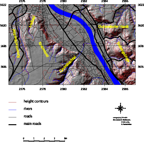
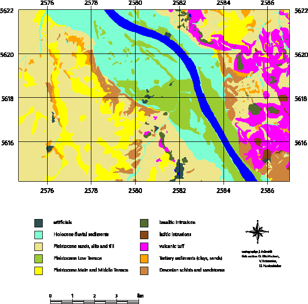
tectonic movement and Tertiary and Pleistocene vulcanic activity. Therefore, west
of the Rhine, today terrace sediments are found above a series
of Tertiary layers (clay, sand and gravel) and a Devonian base layer
(compare figure 2 and figure 3). Pleistocene
tectonic processes uplifted the Kottenforst as a horst with steep slopes
to the Low Terrace of the Rhine. Pleistocene and Holocene
fluvial processes dissected the plateau of the Kottenforst and created
several small valleys (Godesbachtal, Melbtal, Katzenlochbachtal) which
are often donwncutted to the Devonian base level.
The mountainous area of the Siebengebirge
is located east of the Rhine. The Siebengebirge
is formed by Tertiary vulcanic and subvulcanic
activity. Nowadays, eroded basaltic intrusions form the
peaks of the Siebengebirge.
The slopes are covered with vulcanic ashes and with similar tertiary
sediments as on the west side. The valley
floors often reach the Devonian base layer.
Both, on the slopes of the Kottenforst and on the hillslopes in the
Siebengebirge,
landslides are found varying in size and age (Grunert & Schmanke, 1997).
 |
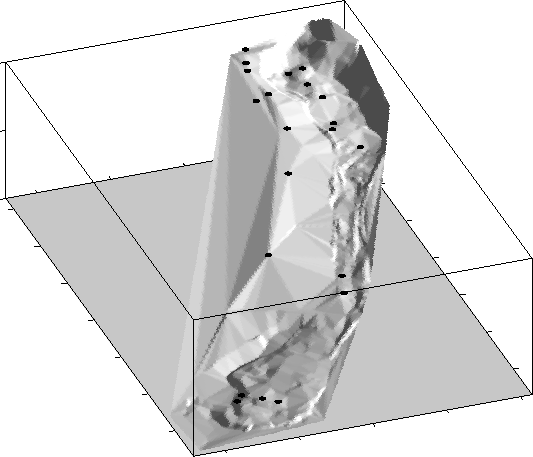
We chose two field sites, which are representative for our research area in morphometric and geologic terms (see above). The first site is a vulcanic peak (Dollendorfer Hardt), located in the Siebengebirge (compare figure 2). There are several mass movements at the side slopes of this peak, including a larger landslide (affected area: 30,000 m2), which we chose for a detailled instrumentation. The second site is the Melbtal, a small valley west of the river rhine, dissected in the Kottenforst plateau (see figure 2). A series of landslides are located at the valley sides (area ranging from 300 to 8,000 m2). The youngest slide (1988) damaged a cemetery and lead to expensive expertises and foundation constructions.
As described in the previous section, our research approach included
different methodologies. Recently, several detailed investigations of
the Dollendorfer Hardt (mappings, drillings, laboratory works, geophysic
subsurface surveys, groundwater monitoring) have been carried out
(figure 4). Different mappings (pedologic, geologic,
morphologic), drillings (core drilling, vane test) and results of laboratory
tests (physical and mechanical soil parameters) are now
available. Groundwater and movement monitoring is carried out.
Supplementary information is available by maps (either in analog or
digital formats) available by official institutions. These include
topographic, geologic and pedologic maps, DEMs in different
resolutions, and various analogeous maps. Moreover, surface and subsurface information (field
and laboratory tests) is available by projects and consultancies working in
the same area.
 |
Although we are presently just in the stage of analyzing the first
field data, first statments about the different characteristics of the
two field sites can be given: At the field site Dollendorfer
Hardt, landslide occurence depends on the existance of steep slopes
and the geologic layer of vulcanic tuffs. Long (up to 500 m) and steep
slopes formed by the vulcanic and tectonic actvity and the
comparatively weak tuffs in high slope positions lead to larger
landslides as in the Melbtal (longer runout distances). The
Melbtal is characterized by lower slope length (up to 200 m) and
hillslopes, which are more gentle. It is dominated by small and
shallow landslides mainly influenced by the existence of heterogeneous
Tertiary sediments. An additional factor is undercutting through the
stream (Engelsbach).
From our point of view integrated and interdisciplinary use of multiple research methods and techniques can lead to a ´best insight´ into the study area, with respect to the studied problem. The combination of different approaches in mapping, surveying and monitoring different parameters reveals a useful combination of information. For example, the geomorphologic, geologic, pedologic and soil mechanic description of the underlying material of a slope involved in landsliding, can help to get a better understanding in the geologic structure and development of the slope. Geophysical surveying techniques can aid in extrapolating point information (like drilling results) and therefore be useful in regional analysis approaches. However, working in a multi-method and multidisciplinary environment means also the difficulty of integrating different sights on the same object. Therefore, the produced data and the used methods to capture, store and analyze the data often are heterogeneous to incompatible.
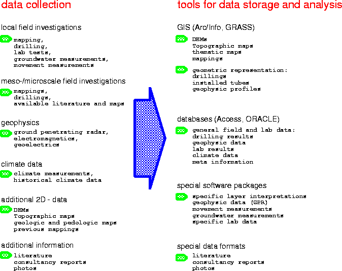
Several tools and software packages are used to store, analyze and visualize the collected data as well as the results of interpreting the data (e.g. geological layer constructions, shear surface reconstruction). Presently the following scheme is used (figure 6):
On top this data scheme and geocomputational concept, several analysis tasks are performed (compare section 2), producing secondary data. These include (1) interpretations of geologic structures on local and regional scales, (2) interpolating three dimensional sediment bodies and landslide bodies, (3) deriving effective soil parameters and (4) slope stability analysis and regional hazard analysis. Until now, the storage of these produced secondary data is only partly realized. Especially the handling of 3D information is a problem to be solved. Therefore, several problems and disadvantages of the used concept to store the data can be identified:
Based on these statements, the conclusion can be drawn, that the development of an homogeneous data model and geocomputational concept in landslide research and, more general, in geosciences is is normaly impossible. That means, we do have a variety of more or less incompatible tools to store and analyze the data, which means lots of time consuming efforts in data bridging and save data recovering. Moreover, the danger of data loss is high, e.g. if a project changes or finishes, if staff changes or if data is transfered from/to external positions (problem of ``data cemetery''). Improvements of this current problems could be reached by more efforts in integrating different data types, improvements of present standards and development of new standards (especially for data documentation), and integrating different standards.
The project OPALIS
aims to support interoperability of various data
sources by providing uniform access to heterogeneous and distributed
sources.
For this purpose, we use the Unified Modelling Language
to represent the data sets through
object models. Aim is to reflect
heterogeneous geoscientific data sets and standards by object oriented
models. Based on this
models, a system will be provided allowing integrated access to the modelled
data sources
(compare Bergmann et al., 1998). This system
will be realized through a OQS (OPALIS QUERY SYSTEM) allowing
new integrated queries (see below). Part of this
initiative is the landslide database for the Bonn area.
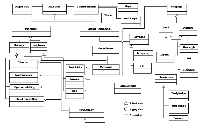
Figure 7 shows a simplified OO-Model of several data
sets of our landslide database (compare section 3)
including different types of mappings, drilling results,
stratigraphic layer interpretations, geophysical data and
others.
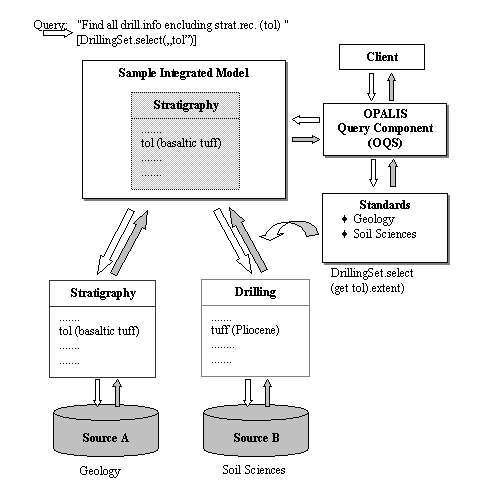
Based on this model, a conceptual query component was applied to show the capabillities of our data model approach. If a query is applied, questioning e.g. a specific geologic term (tol = stratigraphic layer ``basaltic tuff''), the OQS (OPALIS QUERY SYSTEM) can be enabled to extend the query to related namings using the modelled standards. This means the search for ``tol'' will include data sets with different namings for this layer according to domain specific standards. In case of the available drillings and/or mappings these can be e.g. pedologic, geologic and soil mechanic layer descriptions. Therefore the query will deliver as an integrated answer all information from these datasets according to the queried stratigraphic record. Compared to classic systems, this OQS enables the client to query distributed and heterogeneous datasets, rather than using different queries on various systems and therefore simplifies (easy access) and improves (direct access to multiple sources) geoscientific work.
The research question, to which extend landslide activity contributes to slope evolution over longer periods of time is only partly solved in quantitative terms. Although there are some important concepts (frequeny - magnitude, variable thresholds etc.) (Kirkby, 1987), there are only few links between small to regional scale process modelling and conceptual to statistical landform evolution models (Dikau, 1999). We propose to use available stability, hazard and mass movement models and available field data to model statistic parameters of landslides in a spatio - temporal context as a method to fill this gap. The identification of typical situations in terms of the dispositive factors and their relation to thresholds in triggering factors can be a useful possiblity to handle the problem of missing field evidence. The definition of typical field situations with respect to the site environment has to be done using multiple environmental informations. Therefore multisciplinary investigation techniques and results should be used, which requires handling of heterogeneous data sources and modelling techniques.
Handling diverse data sources in combination with the use of various analysis and modelling tools often lead to the problems of (1) weak integration of data sets, (2) weak documentation of data sets and data sources and (3) missing links between the data. This leads to the risk of loosing data or missinterpreting data. Therefore we argue, that data integration is a important research task in landslide reseach and -- more general -- in geosciences. Object oriented modelling techniques can be used to model a diverse data structure in a recoverable and integrative way. This approach could lead to new types of information systems facilitating the integration of multiple data structures and analysis methods. Moreover, data integration can enforce a necessary documentation of specific data handling and data representation in a multidisciplinary environment.
Bergmann, A., Gärtner, H., Breunig, M., Cremers, A. & Dikau, R. (1998), `Design and first steps in the development of opalis', International Society for Photogrammetry and Remote Sensing 32(4), 52-58. Proceedings of the ISPRS Commision IV Symposium ``GIS -- Between Visions and Applications''.
Brooks, S. M., Anderson, M. G., Ennion, T. & Wilkinson, P. (1999), Exploring the potential for physically- based models and contemporary slope processes to examine the causes of holocene mass movement, in Hergarten & Neugebauer (1999b), pp. 205-230. Poceedings from SFB350 - Workshop ''Process Modelling and Landform Evolution'', 1997.
Brunsden, D. & Thornes, J. B. (1979), `Landscape sensivity and change', Transactions, Institut of British Geographers. New Series 4(4), 463-484.
Casale, R., Fantechi, R. & Flageollet, J., eds (1993), Temporal occurence and forecasting of landslides in the European Community, Final report, Vol. I and II of the EC Programme EPOCH, Contract no.90 0025.
Cendrero, A. & Dramis, F. (1996), `The contribution of landslides to landscape evolution in europe', Geomorphology 15,191-211.
Crozier, M. J. (1973), `Techniques for morphometric analysis of landslips', Zeitschrift für Geomorphologie 17(1), 78-101.
Crozier, M. J. (1996a), `Magnitude/frequency issues in landslide hazard assessment', Heidelberger Geographische Arbeiten 104, 221-236.
Crozier, M. J. (1996b), `Runout behaviour of shallow, rapid earthflows', Zeitschrift für Geomorphologie, Supplement Band 105, 35-48.
Dikau, R. (1999), The need for field evidence in modelling landform evolution, in Hergarten & Neugebauer (1999b), pp. 3-12. Proceedings from SFB350 - Workshop ''Process Modelling and Landform Evolution'', 1997.
Dikau, R., Brunsden, D., Schrott, L. & Ibsen, M.-L., eds (1996), Landslide recognition, Vol. 5 of Publication (International Association of Geomorphologists), Wiley.
Francis, S. C. (1987), Slope development through the threshold slope concept, in M. G. Anderson & K. S. Richards, eds, `Slope stability', Wiley, pp. 601-624.
Grunert, J. & Hardenbicker, U. (1991), `Hangrutschungen im Bonner Raum - ihre Genese und Kartierung für Planungszwecke', Zeitschrift für Geomorphologie, Supplement Band 89, 35-48.
Grunert, J. & Hardenbicker, U. (1993), `Gravitative Hangabtragung im Bonner Raum während des Holozäns', Würzburger Geographische Arbeiten 87, 325-338.
Grunert, J. & Schmanke, V. (1997), `Hangstabilität im Südwesten Bonns', Geographische Rundschau 49(10), 584-590.
Hamre, T. (1994), An object-oriented model for measured and derived data varying in 3d space and time, in T. C. Waugh & R. G. Healey, eds, `Advances in GIS Research Proceedings', Vol. 2, pp. 868-881. Sixth International Symposium on Spatial Data Handling.
Hardenbicker, U. (1991), `Verbreitung und Chronologie der Hangrutschungen im Bonn er Raum', Arbeiten zur Rheinischen Landeskunde 60, 9-18.
Hardenbicker, U. (1993), `Neue Ergebnisse der Hangrutschungsforschung im Bonner Raum (Südrand der Niederrheinischen Bucht)', Berliner Geographische Abhandlungen 78, 155-174.
Hergarten, S. & Neugebauer, H. J. (1999a), Self-organized criticality in landsliding processes, in Process modelling and landform evolution (Hergarten & Neugebauer, 1999b), pp. 231-249. Proceedings from SFB350 - Workshop ''Process Modelling and Landform Evolution'', 1997.
Hergarten, S. & Neugebauer, H. J., eds (1999b), Process Modelling and Landform Evolution, Vol. 78 of Lecture Notes in Earth Sciences, Springer. Proceedings from SFB350 - Workshop ''Process Modelling and Landform Evolution'', 1997.
Kirkby, M. J. (1987),
General models of long-term slope evolution through mass movement, in M. G. Anderson & K. S. Richards, eds, `Slope stability', Wiley, pp. 359-379.
Palmquist, R. C. & Bible, G. (1980),
`Conceptual modelling of landslide distribution in time and space', Bulletin of the International Association of Engineering Geology 21, 178-186.
Raper, J., ed. (1989),
Three dimensional applications in Geographical Information Systems, Taylor&Francis.
van Beek, L. P. H. & van Asch, T. W. J. (1999),
A combined conceptual model for the effects of fissure-induced infiltration on slope stability, in Hergarten & Neugebauer (1999b), pp. 147-167.
Proceedings from SFB350 - Workshop ''Process Modelling and Landform Evolution'', 1997.