![]()
![]()
![]()
This paper examines surface elevation based on samples of terrain modelling and field survey. One structure has been used to digitally represent this study: Lattices and Triangular Irregular Networks (TINs). GIS based on digital elevation models, offers the potential to be able to map lineaments and slope angles to predict surface processes such as lava flow and erosion. The prediction of flow directions by the terrain model and subsequent erosion are correlated with field results.
Keywords: Mount Cameroon, lava flow, erosion, lineament, digital elevation model, GIS, neotectonic terrain
The use of terrain modelling in representing the surface of Mount Cameroon is an appropriate application which is undergoing regular updating to obtain the best possible terrain representation. In this paper terrain modelling is used to demonstrate surface relief features and the direction of lava flow. The accuracy of the relief features, direction of lava flow and extent of lava erosion were investigated in the field.
Many hypotheses have been proposed describing the nature and origin of Mount Cameroon: 1.Vertical movements which created either a series of horsts and grabens bounded by SW-NE normal faults (Passarge, 1909; Geze, 1943; Gouhier et al., 1974; Deruelle et al., 1983, 1984) or continental rifting (Lasserre, 1978; Jacquemin, 1981). Such a rift could have been produced directly by a thermal anomaly in the asthenosphere (Dunlop, 1983; Fitton, 1983), a sort of hot spot (Tchoua, 1974; Duncan, 1981). This hypothesis implies a Recent (or Cretaceous Tertiary) stretching mechanism in the lithosphere. 2.Rejuvenation of a major fault. This fault zone is either supposed to have existed before the opening of the South Atlantic Ocean in the prolongation of the Pernambuco fault (DAlmeida and Black, 1967; Louis, 1970, 1978) or was related to an early stage of seafloor spreading (Upper Cretaceous).
This volcano is the only other volcano outside the Mediterranean to have a documented eruption before the time of Christ at least 15 eruptions since 450 BC.
Digital elevation model (DEM) is defined here as an orderly array of numbers that present the spatial distribution of elevations above some arbitrary datum in a landscape. It may consist of elevations sampled at discrete points or the average elevation over a specified segment of the landscape, although in most cases it is the former. DEMs are a subset of digital terrain models (DTM) defined in this paper as ordered arrays of numbers that represent the spatial distribution of terrain attributes. The application of digital elevation modelling in this region to analyse the impact of lava erosion on the terrain is a new concept.
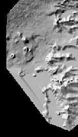
A Triangular Irregular Network (TIN) topology for the area was created by manually digitising a 1 : 50 000 topographic map which approximated the terrain surface by a set of triangular facets. Most TIN models assume planar triangular facets for the purpose of simpler interpolation in applications such as contours (Lee, 1991). The purpose of using a TIN method in this study is to convert the dense vector data to a TIN model in such a way that the surface defined is as close to the DEM surface as possible.
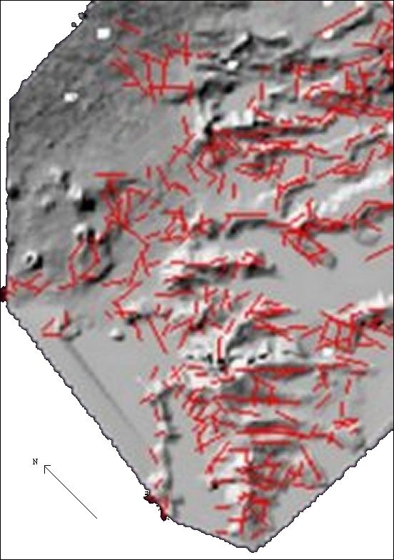
The surface DEM mapping has been applied in this study as an alternative derivative for the detection of brittle tectonic structures such as fractures, faults, large-scale fractures and fracture zones. The scale of the mapped fractures are commonly denoted as lineaments (OLeary et al., 1976) which control the direction of lava flow downslope and influence the drainage pattern. The extraction of lineaments from a digital elevation model entailed a subjective visual identification and manual digitising. Lineaments in a DEM are identified by a drop in elevation for a short distance (Wladis, 1999), therefore they have been described by a certain frequency in this region in terms of their representation in a digital elevation model. The digital elevation model was transformed into a shaded relief image in which different effects were achieved by varying the value of surface / sun orientation, sun elevation angle and vertical exaggeration to obtain the best brightness information of the shaded relief to identify and map lineaments (Nama, 1999) (Fig. 2).
Field observations undertaken in this region, verified the accuracy of mapped lineaments on DEM and the predicted direction of lava flow.
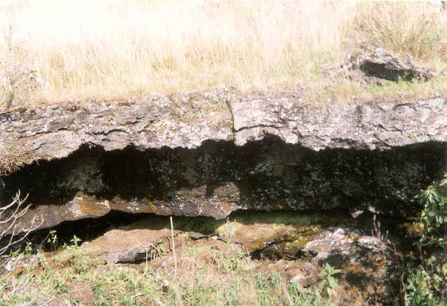
The details of whether lava channels form by predominantly erosional (thermal or mechanical) or constructional processes or by laminar flow remain debatable. It is likely that volcanic channels form under various non-unique combinations of some or all of these conditions. The goal was to assess field evidence for erosion of substrate material by flowing lava. Mechanical erosion was considered in which preflow material was removed much like bed load in a fluvial stream, and thermal erosion in which preflow material is melted or partly melted and mobilised by flowing lava. In order to understand the conditions under which erosion occurs and to determine the scale of erosion, I investigated basaltic tube-fed flows, basaltic caves, collapsed basaltic tubes and lava excavation of the Limbe Idenau road.
The criteria used to assess erosion by lava are (1) active lavas observed or inferred to downcut, (2) direct evidence of thermal erosion (i.e., melted substrate), (3) lava undercut into preflow material, (4) geochemical signature showing assimilation of preflow materials into the eroding flow, (5) assimilated fragments of preflow material into the eroding flow, (6) exposed paleosols/scoria in wall of lava tube.
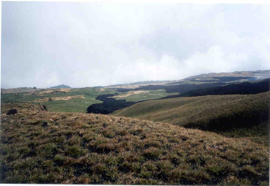
The use of DEM to determine the flow of lava and subsequent erosion on the slopes of the south west flank highlights three important factors (1) lineament orientations (2) slope facets, and (3) width of depressions. In the field, observations revealed a correlation between the orientation of faults and fractures and the direction of lava flows. In areas where faults lines have been eroded successively by ephemeral flows and runoffs, wide valleys with average widths of 6 metres have been formed increasing the holding capacity of runoff and lava flow downhill.
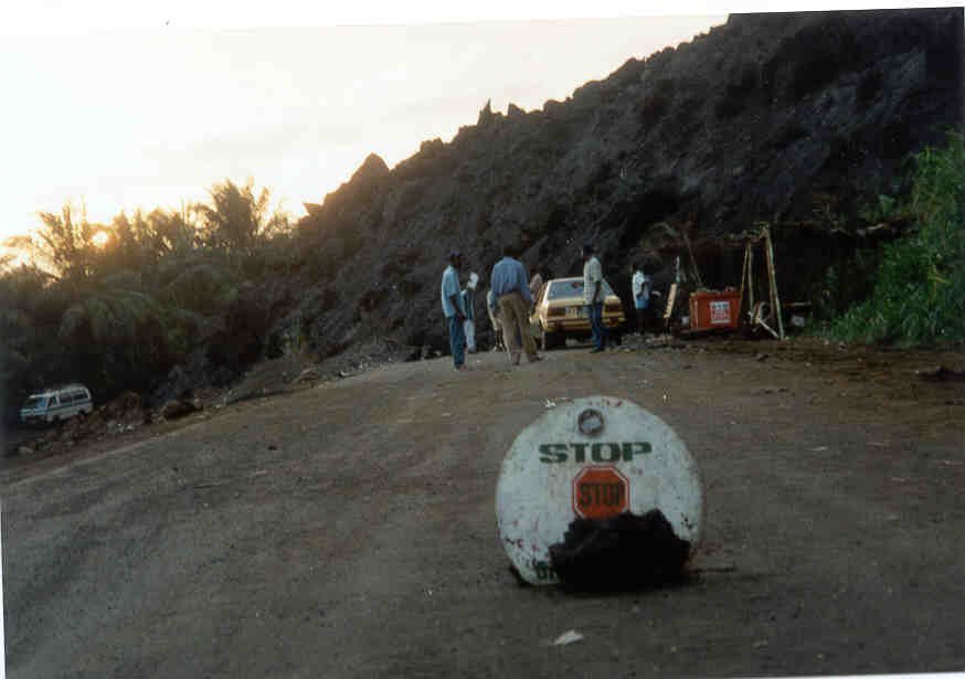
On the steeper slopes above an altitude of 1200 metres, the velocity of lava flow is high. For example, the 1982 volcanic eruption had a velocity of aa lava flow of 4 m/s on the upper steep slopes at an altitude of 2700 metres and reduced to 2 m/s at 2500 metres. During the March April 1999 eruption, the aa lava flow travelled swiftly down the steep upper slopes, but slowed to 10 25 m/ hour on the gentle slopes and reduced to 7 m/ hour on the gentle sloping coastal terrain, eroding the Limbe Idenau road on April 15, 1999. When it eventually ceased, all forward movement on April 17, 1999, the 12 metre thick aa blocky lava had traces of consolidated volcanic soil which was evidence of lava erosion in this region. The May June 2000 eruption at an altitude of 4000 metres flowed at a velocity of 10 m/hour near the vents and increased to 20 25 m/hour on the steep upper slopes. The lineament orientation, slope angles and width of depressions have also influenced the flow pattern and erosive potential of this latest eruption.
Déruelle, B. and Regnoult, J.M, 1983, Carte télé-interprétative des linéaments de la République Unie du Cameroun au Nord du 4ème parallèle (1/1 000 000). Minist. Mines. Energie, Direction des Mines et de la Géologie, Yaounde, Cameroun, 8.
Duncan, R.A., 1981, Hot spots in the southern oceans, an absolute frame of references for motion of the Gondwana continent. Tectonophysics, 74: 29-42.
Dunlop, H.M., 1983, Strontium isotope geochemistry and potassium-argon studies on volcanic rocks from the Cameroon line, West Africa. PhD Thesis, Univ. Edinburgh, 347 pp.
Fitton, J.G., 1983, Active versus passive continental rifting: evidence from the West African rift system. Tectonophysics, 94: 473-481.
Geze, B., 1943, Géographie physique et géologique du Cameroun Occidental. Mémoir du Museum National dHistoire, Paris, XV11, pp. 12
Gouhier, J; Regnoult, J.M., and Déruelle, B., 1983, Géologie et structure linéamentaires au Cameroun (du lac Tchad a la Sanaga): apport des images Landsat. Annale de Faculté des Sciences, Yaounde, 1, 2, 2, 3-4.
Jacquemin, H., 1981, Contribution a létude volcanique du Cameroun (Ligne du Cameroun-Adamaoua). Ann. Fac. Sci., Univ. Yaounde, Cameroun, 17: 3-48.
Lasserre, M., 1978, Mise au point sur les granitoides dits ultimes tertiares du Cameroun: gisement, pétrographie et géochronologie. Bull. B.R.G.M., 2e Sér., 4: 148-159.
Louis, P., 1970, Contribution géophysique à la connaissance géologique du bassin du Lac Tchad. Mém. O.R.S.T.O.M., 42: 311pp.
Louis, P., 1978, Gravimétrie et géologie en Afrique occidentale et centrale. Mém. B.R.G.M., 91: 53-61.
Nama E.E., 1999, Lineaments in the Mount Fako region, West Africa: a GIS approach. Annual Conference of the Royal Geographical Society with the Institute of British Geographers, University of Leicester, 4 7th January 1999 pp177
Nama E.E., 2000, Modelling variables to predict landslides in the sw flank of the Cameroon Volcanic Line, Cameroon, West Africa, Proceedings of the Asian Conference on Unsaturated Soils, UNSAT ASIA 2000/ Singapore/ 18-19th May 2000, pp 813 - 817
OLeary, D.W., Friedman, J.D., and Pohn, H.A., 1976, Lineaments, linear, lineations: Some proposed new standards for old terms. Geological Society of American Bulletin, 87, 1463-1469.
Passarge, S., 1909, Der vulkanische Ausbsuch des Kamerun-berges. Dent. Kolonialblatt., 20, 628 pp.
Tchoua, F., 1974, Contribution à létude geologique et pétrographique de quelques volcans de la ligne du Cameroun (Monts Manengouba et Bambouto) Doctoral thesis, Univ. Clermont- Ferrant, 347 pp.
Wladis, D., 1999, Automatic lineament detection using digital elevation models with second derivative filters. Photogrammetric Engineering and Remote Sensing, 65, 4, 453-458.