![]()
![]()
![]()
The traditional creation of a global uniform database is considered to be very important, but traditional methods are not the only way. An alternative database is a digital map library (DML). This can be generated for particular areas as an important parallel source of different views and scientific approaches that can be readily used by a wide range of specialists with the help of fast and easy-to-use desktop mapping systems. This is also important with respect to working with features and attributes that vary in both space and time. Users may extract the data they need in current research, starting from the base geographic map, compare them, make a decision, add their own data, make changes, and finally, produce their own new map. Modern multi-layered maps can be developed producing an atlas containing, for example, buried shapes of objects of geological shears, additional paleogeographic information or, at least, a list of recommended relevant data accessible from the DML. Attention is paid to visualization of different information on the map, like descriptions attached to spatial objects, images of rocks, key fragments of seismic lines, etc., using OLE Linking and Embedding, so that the final map appears like a complete report of the area.
Explanatory volumes for selected areas are prepared in Hypertext Mark-up Language in the form of a web site to make the GIS data available to the international community for scientific and educational purposes. Complementary raster-based animated sketch maps and three-dimensional models and sections are used to visualize spatio-temporal data when trying to make geology more understandable to the general public.
All stages of the geological mapping have long history, traditions and rules, especially for the creation and getting up the governmental geological map series at certain scales. First attempts of preparation of new generation of computed maps were aimed mostly on the digitising of a hard paper copies. Resulting digital versions were used mostly for printing and correction purposes, being isolated from geologists either by special formats, or by the necessity of the long education curve. However, with the growing use of graphic workstations and personal computers, and increased role of the Internet and Intranet, development of a new geological mapping strategies with increased involving of computational techniques is on the rise.
Serious now-a-day efforts are aimed on the creation of a global uniform database, and on progress of a true easy-to-use distributed computing environment. The compilation of such database in progress is very important work, but at the moment effective using of the results is not obvious. In addition to common technological problems, like the active location update scheme and failure restoration, or dynamical reaction to changed network states, the geological science brings its own. Some of them are constant updates in stratigraphic division and correlation, numerous and often contradictory interpretations, data scarcity, geological variations, different methods used in field data collecting, role of competence and experience in geological mapping that can not be estimated in the uniform database at the moment.
DML is combined to help geologists to create the preliminary geological base map from a CD-Rom during the field work either, when the network is unreachable. That is important to have such preliminary model, translating location of observations on it, adding new records and correcting immediately in the field.
In recent investigations Golden Software products ( Didger 2, MapViewer and Surfer 7 ) were tested, and this software shows stable work and ability to solve numerous geological tasks very effective. Graphics of this paper was prepared from different types of the maps created using Golden Software packages. It is important to notice user-friendly interface, allowing to produce base maps, thematic maps, contour maps, etc., or to perform 3D Surface mapping and different computations without long training and assistance, that is urgent for geologists without special GIS education.
For example, spatial DML data in the form of points, polylines and areas, like geological boundaries, can be extracted easily in relation with area and code that stores the range of the division either. Local utilities allow to resample boundaries, with breaking and extracting the required fragment. Functions of criteria extraction, thinning, and smoothing for polylines and polygons can be performed in numerous GIS - related software.
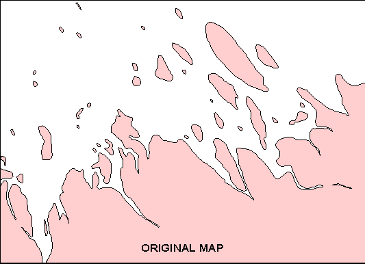
The image above illustrates simplest elements of graphic generalization in Didger 2, performing criteria extraction (measured properties - area) first, and deleting areas less then "n" square kilometres, with further vertex averaging thinning, and final smoothing of a reshaped boundary.
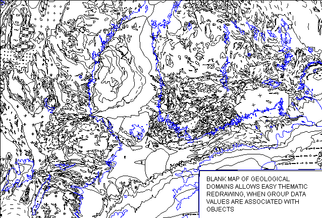
General principles of the DML are simple and probably more or less common: there are storages of data, grids, and mostly thematic boundaries converted in Latitude/Longitude (decimal degrees), with additional comments about the authors, year, source map, original scale, brief description, opinions.
For the MapViewer users, major spatial data (that supposed to be most updated) are arranged in complete base maps with the mentioned comments, because it is simple to select any boundaries from the "List" by ID, and transfer them on a new map easily with the help of the possibility to export "selected objects only". Such multi-layered maps exhibit simple geological atlas containing, for example, buried shapes of objects of geological shears, additional paleogeographic information or, at least, a list of recommended relevant data accessible from the DML.
In the MapViewer the arrangement can be effectively realised as a Hatch Map. Users may easily reorganize map selecting different variables. For example, "Geological Map" allows to redraw blank map into a geological one, while different ("user defined") specification of number of ranges may regroup "geological families" with their joining when decreasing a number of ranges, or backwards. Specification of a single range type with determined number enables to fill by colour only required group of geological objects. For such map it is better to use manually assigned common colours instead of gradational ones.
Additional pre-defined variables allow to assign a colour spectrum to the first-order stages. Say, the variables subMAP of the AR-PR basement, subMAP of sedimentary cover, subMAP of Caledonian belt for the Fennoscandia and adjacent areas allow to make colour / pattern fill of groups of this stages only.
Other variables of "Transformer" Map include the Tectonic Map, Isotopic Age Map, Hard rock type Map (Petrographic Map of the crystalline rocks), Sediment type Map (Lithological Map of the cover), Erosional resistance Map, and some others.
Some principles of this map type are illustrated in the fragment of the Geological Map of the Fennoscandia and Adjacent Areas (A. Amantov, Rogaland Research Special issue, report no. 1998/380, Stavanger, Norway).
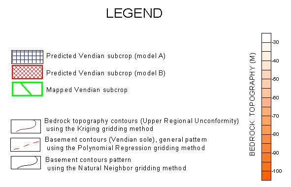
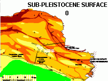
At the moment, partial automation with creating of several preliminary models is usually performed for the platform areas, where it is more or less easy to forecast strata bedding and lateral changes, even in the case of poor data. Outcrops or subcrops of mapped divisions are getting as grid-produced intersections of surfaces of the sole of the mapped unit and the bedrock topography. Worse results are typical for the areas strongly affected by faulting, or with dissected bedrock surface and thick Quaternary sediments, like the Baltic Shield's margin, where the experience of geologist allows, for example, to forecast the behaviour and form of deep glacial tunnel valleys. However, the modelling gives satisfactory draft in this case either, as shown on the picture.
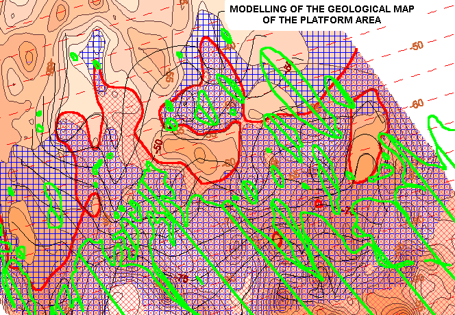
The gridding and relevant computations were performed using Surfer 7, where the process can be automated using the Scripter Basic Language. Gridding with account of the fault lines and possibility to use variogram grid approach should be mentioned among numerous new useful advanced features of this software.
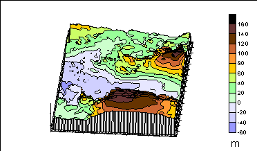
Explanatory volumes for selected areas are prepared in Hypertext Mark-up Language in the form of a web site to make the GIS data available to the international community for scientific and educational purposes. Complementary raster-based animated sketch maps are based on the original layers of the digital vector maps. Animation seems useful to illustrate the pattern of transgressions - regressions, erosion activity, pattern of changes of the exhumed and epigene surfaces of the bedrock topography, retreatment of scarps in geological time, etc. For example, the following picture was produced from the real map of the bedrock topography of the eastern part of the Gulf of Finland, originally combined in the MapViewer.
It illustrates supposed animated model of the Upper Pliocene - Pleistocene erosion and the development of glacial tunnel valleys in the Vendian platform sediments, when different height levels and (or) surfaces are shown by colour fill, while figures indicate age.
Usually all animations of such kind have Java Script control of speed and possibility to stop and continue from the required image of the sequence.
The other example is animation of the Barents Sea basin and high pattern with average vertical motions of structures. It is based on the MapViewer Prism Maps, when variable height prisms represent different average values of the basement during several stages.
More complicated sketches exhibiting horizontal displacements involve additional layers with rearrangement of areas of the Base Map.
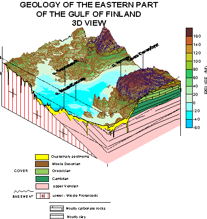
Three-dimensional models and sections, based on grid produced 3D surface mapping, are used to illustrate geological, geomorplological and tectonic features of the area.
This rotated model shows the relief pattern of the eastern part of the Gulf of Finland and adjacent onshore areas. Original models were prepared using Surfer 7.
Such models are more effective with drawing additions of geological sections on "sides". In the following example they mark the erosional origin of major landforms shown.
Rotating models of such kind may display lateral differences of the geological situation, but their preparation takes some time. However such illustrations seem to be effective additions to faster comrehension one or other "key" area to geologists, and to make geology more understandable to the general public.