


Storing Voronoi diagrams in geographical databases
Jean-François Hangouët
Laboratoire Cogit
Institut Géographique National
2-4 avenue Pasteur
94165 Saint-Mandé Cedex
France
E-mail: Jean-Francois.Hangouet@ign.fr
Abstract
Two-dimensional cartographic wholes are stored in the computer as mono-dimensional
lists of so-called geographical objects. Although disposition of objects
is as desirable as individual presence for cartographic representation
(generalization) and geographical analysis,
configurations are only
implicitly stored, by means of coordinates. While the full reconstitution
can be said to be left to the eye and appreciation of the human operator
upon displaying, any automated handling of geographical data involves automated
reconstruction of some kind.
Reconstruction is often performed with purpose-oriented tools,
the more obvious and the more famous of which may well be the Delaunay
triangulation, clearly dedicated to the elicitation of proximity relationships.
Either as such, or in the dual form of the Voronoi diagram on points, we
consider it however to be a purpose-oriented tool indeed inasmuch as before
triangulation can be computed, specific points from the data must be chosen,
the constraint being that they be representative enough for the wished-for
application.
A similar yet bias-free structure exists: Voronoi diagrams on
segments, brought into geomatics by Christopher Gold. These diagrams also
cast separate cartography-worthy objects into a planimetric whole, by allocating
portions of the plane with closest points to every atomic part from the
features (every segment, every junction). But now, involving everything
from the available geometry of the features, they account fully of them,
and can be said to be data-induced structures. Such diagrams can thus be
pre-computed, and it is the aim of this paper to describe in what form
they can be stored to meet efficiently quite remarkable a range of basic
spatial queries.
The paper deals not actually with how to compute Voronoi diagrams
on segments (referring to literature from the field of computational geometry),
but with how, once computed, they can be stored in relation to the available
spatial data. One "intrinsic" diagram per object, and combination methods
for "combined diagrams" when several objects are retrieved together, are
advocated. Edges of a Voronoi diagram are geographically classified as
"internal edges" (within the contour of an object), "external edges" (left
or right from an object, separating components of its own trace), "interface
edges" (separating components from two different objects). Edges are also
geometrically classified (segments of lines equidistant between point and
point, of lines equidistant between segment and segment, of parabolas equidistant
between point and segment). Useful attributes for edges are described (end
points, minimal-maximal distances to objects etc.) as well as basic calculation
methods (length of an edge, where to find on it a point at a given distance
from the object etc.).
In addition, a variety of basic but recurring and often fastidious
spatial queries are shown to be made simple not only by using Voronoi diagrams,
but by using them with the advocated structuration. Convex hull, Minimum
Spanning Tree, dilation, erosion, opening, closure, skeleton, Hausdorff
distance between lines, Hausdorff distance between areas, the Bouligand-Minkowski
fractal dimension, and water-lining (as re-introduced recently by Albert
Christensen, yet from another point of view) are described shortly.
Keywords
Voronoi diagrams, geographical databases, cartometry, automated spatial
analysis, computational geometry
1. Introduction
The paper is meant to describe how Voronoi diagrams can be integrated in
vector geographical databases and GISs. In this introduction, a few preliminary
considerations are made, separately (first on vector GISs then on Voronoi
diagrams), not to expose detailed theories of either, but to contextualize
the present work in broad terms and with general references from the two
perspectives.
1.1. Vector geographical databases
In this section, vector geographical databases are presented with an emphasis
on the representation of geometry.
1.1.1. Generic description
In geographical databases, geographic features are represented by means
of objects of various geographical types. What distinguishes vector from
raster databases is the way the inscription of the object on the ground
is stored: by means of pools of pixels in raster databases, by means of
successions of coordinates in vector databases. The paper addresses vector
databases.
1.1.2. The geometry of objects
Accordingly, what is meant by "geometry" of an object in the following
is the list of the successive points used to denote its inscription on
the ground. We consider it to be equivalent to the list of the successive
segments, those joining the successive points. This consideration however
needs justification, as general conceptual models for "geometry" usually
make room for interpolations of other kinds [see e.g. the definition of
GM_CurveSegment, (OpenGIS 1999: 20): the list of points is equipped with
the indication of their interpolation]. Our restriction is motivated by
at least three observations:
-
Geographic data are captured point-after-point, not curve-by-curve.
-
Basic geographic data in vector GISs are stored as lists of points, not
as curve functions.
-
The traditional way of denoting geographic limits (coasts, borders...)
and geographic traces (roads, rivers...) is to indicate meaningful posts,
between which interpolation is made by straight lines. This for example
is how routes are usually described, this is also how Strabo advocates
how the limits of the world should be apprehended:
it will suffice to
fill out and complete the outline of (the inhabited land) by joining with
a straight line the extreme points reached on the coasting-voyages made
on both sides of the inhabited world...(Strabo 2.5.5)
The underlying "explanation" behind each of the three reasons is, of course,
that straight lines are easier to deal with than strangely-shaped curves
(which is true for computer-assisted capture and computer storage, and
for the general apprehension of geographic phenomena as well).
1.1.3. Location vs. configuration
This geometry of traces and contours provides no indication beside
location:
shapes of objects, dispositions of groups of objects, mutual distances
between objects are contained in a latent state only. These are usually
elicited by application-specific methods (e.g. selection in a specific
box or a perimeter, or Delaunay or Voronoi structures on specifically-chosen
points, or segmentation algorithms with specific thresholds etc.), before
the application itself (e.g. generalization, or expert object analyis,
or integration of exogeneous data etc.) may be said to start.
The Voronoi diagram on the full of the available geometry (i.e. on
points and segments), as described section 2 of the paper, is a way to
(re)constitute the configuration of objects independently from any application,
yet with benefit for many applications since recurring difficult operations
are made easier with it, as illustrated in section 3.
1.2. Voronoi diagrams
Voronoi diagrams turn out to be useful structures to model the natural
cimentation in their global space of objects given seperately.
1.2.1. General definition
Objects of a same space (not a polygon and a differential equation) are
given separately.
The given group of objects is called the figure in the following.
Each separate object is called a site in the following.
The Voronoi diagram of the figure is the attribution, to each object,
of all the points in the space that are closest to it than to any other
object, according to some distance.
Cells are thus constituted. Cells are limited by boundaries
equidistant with other sites.
1.2.2. Varieties
Voronoi diagrams, according to this general definition, may be defined
in spaces of any dimension (2, 3, n...), with any kind of distance
(not necessarily the euclidean distance), on any kind of separated objects
(points, and/or segments, and/or curves...), with any kind of distance
minimality (minimal, second-minimal, nth minimal etc.). (Okabe et
al. 1992) describe many varieties.
1.2.3. Computation
The computational time complexity of Voronoi diagrams is O ( n . log n
), when the figure is composed of n sites. Several optimal or practical
strategies have been designed (divide-and-conquer, incremental, sweepline
etc.). It is not the purpose of this paper to describe construction algorithms,
as extensive documentation can be found in (Okabe
et al. 1992),
(O'Rourke 1995), (Boissonnat & Yvinec 1995), and from
Computational
Geometry Resources, Prisme
project, and of course Christopher Gold's Voronoi
Web Site. Martin Held has produced a recent publication on the subject,
an extended abstract of which can be found here.
1.2.4. Applications
Christopher Gold's Voronoi Web Site
shows that Voronoi diagrams are everywhere, from the eggs in the frying
pan to the galaxies in the Universe, and provides extensive lists of applications
of Voronoi diagrams in many fields of science and of technology.
1.2.5. Voronoi diagrams in this paper
The Voronoi diagrams here described for vector GISs are those introduced
into geomatics by Christopher Gold during the last twenty years (see the
collection of his Voronoi-related papers here),
and have the following characteristics:
-
Sites are points and segments,
-
Space is the euclidean plane.
Cells are limited by edges that are segments of straight lines (of
bisector lines when equidistance is two segment sites, of mediatrix lines
when equidistance is between two point sites) and segments of parabolas
(when equidistance is between a segment site and a point site).
In this paper, both by convention and for practical reasons, the endpoint
of segment is considered to make a separate site, and the line orthogonal
to the segment at the endpoint is considered to be the Voronoi edge between
the two sites. This, in all, thus makes 4 kinds of edges (see figure 1
below).
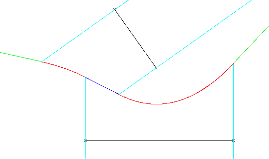
Figure 1: The four kinds of Voronoi edges
parabola (red), mediatrix (green), bisector (deep blue), degenerate
(light blue)
Edges meet at nodes.
Note: all segments and points composing the geographical objects' geometries
- i.e. all the available geometrical information - are taken into account
by the diagram.
2. Storing Voronoi diagrams
This section describes how Voronoi diagrams may be stored in relation
with
the geographical objects that originate them (parts of them are precomputed,
and on-the-fly combinations are made possible), and what useful data and
methods may be stored in addition to the mere shapes of the diagrams's
edges.
2.1 Conceptual model
2.1.1. Necessary infra-structure
Basic vector data need some kind of reformulation so that their Voronoi
diagram might be associated efficiently:
-
every component of the geometry, i.e. every intermediary vertex
and
every pair of successive vertices (i.e. every segment), must have a local
identifier (unique in the context of the given object only, not necessarily
in the context of the whole database). Such an identified component is
called an element in the following.
-
every segment component must be oriented, i.e. made to show a "left" side
and a "right" side.
-
it helps if the orientation of the segment components is consistent all
along the object (i.e. what is on the "left" of a next segment is on the
"left" of the given segment). In which case every point component might
also be "oriented", as follows: if the angular field of "rightness", as
measured from the point between the two successive right sides of the segments,
is greater than PI, then the orientation of the point is "right", else
it is "left" (see fig. 2. We will not go into the reasons for this "orientation"
of points - basically, it consists in marking the contribution of the point
to the direction of the curve: when you are on the right side of a segment,
when the next segment goes somewhat to the left, the articulation point
is rightest indeed, while when the next segment goes somewhat to the right,
the articulation point is left indeed).
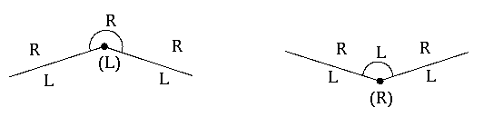
Figure 2: "Orientation" of a vertex
2.1.2. Diagram-data association
Relationally speaking, the association of the diagram with the data may
be described as follows:
-
Static relation: A table is stored per object:
(edge id, element1, side1, element2, side2)
-
Dynamic relation: Upon combination, when several objects need to be processed
together, a table is created on the combined diagrams:
(edge id, object1, element1, side1, object2, element2,
side2)
In the following,
-
edges that separate two different objects are called interface edges;
-
edges within a contour (all of a same side, indicating "inside"), are called
internal edges;
-
edges without a contour (all of a same side, indicating "outside"), are
called external edges;
2.2 Attributes per Voronoi edge
To draw a Voronoi diagram is to address the human mind. To make the diagram
tractable by the computer, explicit information must be stored in addition
to the mere geometric shapes of the edges. Necessary or useful attributes
per edge are illustrated in figure 3, and listed in details in sections
2.2.1 to 2.2.10 below. Most of these are necessarily computed, in this
or a similar form, during the computation of the diagram itself: no time-consuming
extra computation is needed.
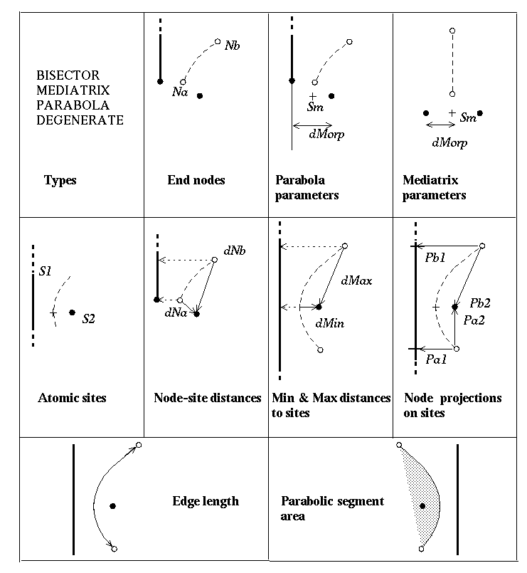
Figure 3: Attributes per Voronoi edge
2.2.1. Type
Edges may be of the following types:
-
BISECTOR: Both separated atomic sites are segments.
-
MEDIATRIX: Both separated atomic sites are points.
-
PARABOLA: One atomic site is point, the other is segment.
-
DEGENERATE: Edge at an endpoint of a segment.
2.2.2. End nodes
Na is one of the end node of the edge (i.e. a pair of coordinates),
Nb
is the other.
2.2.3. Parabola parameters
Two data are stored specifically for an edge of the PARABOLA type:
-
Sm: pair of coordinates of the vertex of the whole mathematical
parabola,
-
dMorp: distance "morp-hological", i.e. the focal distance (from
the focus of the parabola to its directrix)
2.2.4. Mediatrix parameters
Two data are stored specifically for an edge of the MEDIATRIX type:
-
Sm: pair of coordinates of the middle point between the two separated
atomic sites,
-
dMorp: distance "morp-hological", i.e. half the distance between
the two separated sites.
2.2.5. Atomic sites
S1 and S2 are the two atomic sites separated by the edge
(the two "elements" introduced in section 2.1).
2.2.6. Node-site distances
dNa = d(Na,S1) and dNb = d(Nb,S1) are the distances from
the nodes of the edge to the sites.
2.2.7. Min and Max distances to sites
The Max distance from the edge to the sites is achieved at one of its nodes:
dMax
= Max (dNa , dNb). The minimal distance, when the edge is a MEDIATRIX
or a PARABOLA, may be achieved along the edge: if Sm is on the edge
indeed, then dMin(E) = dMorp else
dMin(E) = Min (dNa , dNb).
2.2.8. Node projections on sites
Four data are stored:
-
Pa1 (a pair of coordinates) is the projection of node Na
on S1,
-
Pa2 is the projection of node Na on S2,
-
Pb1 is the projection of node Nb on S1,
-
Pb2 is the projection of node Nb on S2.
2.2.9. Edge length
For edges of the BISECTOR, MEDIATRIX or DEGENERATE types, length is the
euclidean distance between the two nodes.
For an edge of the PARABOLA type,
u being either of the two unit vectors directing the segment
site, and with
ka = min (SmNa . u , SmNb . u),
kb = max (SmNa . u , SmNb . u),
SmNa denoting the vector from Sm to Na, length
is:
Le = dMorp/2 . [ Arg sh (kb / dMorp) -
Arg sh (ka / dMorp) ]
+ dMorp/4 . { sh [ 2 . Arg sh ( kb / dMorp ) ] - sh
[ 2 . Arg sh ( ka /
dMorp ) ] }
2.2.10. Parabolic segment area
With the same notations, and introducing:
if ka = SmNa . u then da =
dNa and
db = dNb
else da = dNb and db = dNa,
the area of a parabolic cap is:
Ar = 1/2 . (kb - ka).(dNa + dNb
-
dMorp) - 1/3 . [ (db - dMorp/2).kb - (da
- dMorp/2).ka ]
Note: Attributes from 2.2.6 to 2.2.10 may be stored as methods, to be
evaluated only when triggered.
2.3 Basic formulas
This section describes elementary functions to deal with points on edges
and sites, and with distances from diagram to figure. Sections 2.3.1 to
2.3.7 find their illustrations in figure 4 below.
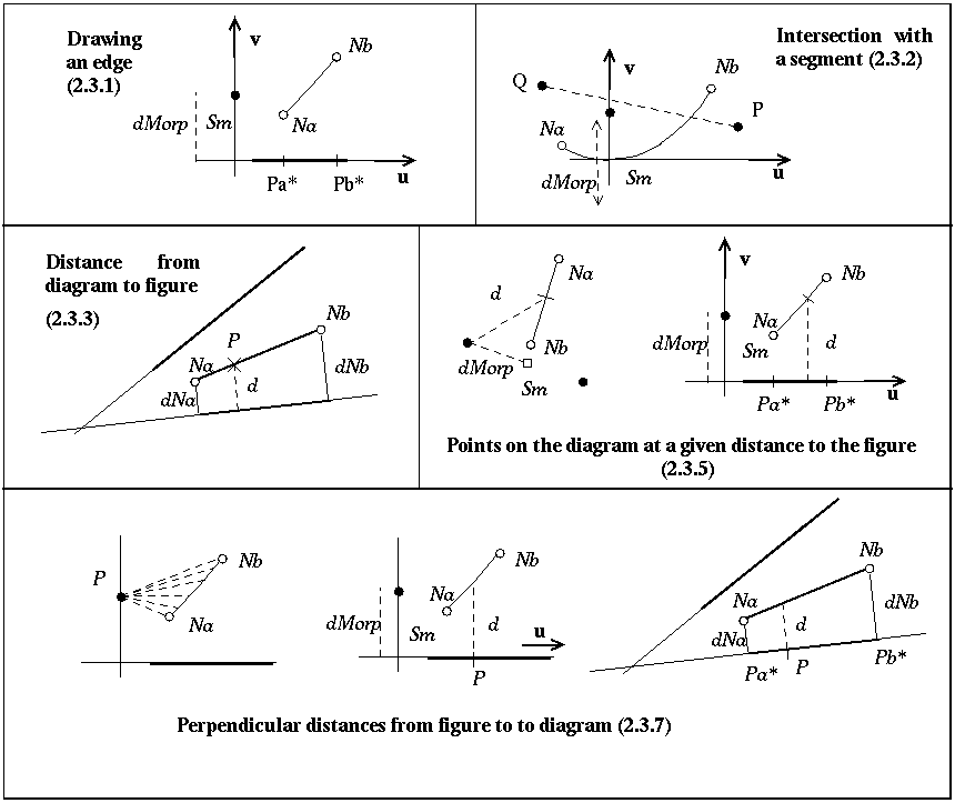
Figure 4: Illustrations for elementary functions
2.3.1. Drawing an edge
To draw edges of the BISECTOR, MEDIATRIX or DEGENERATE types is to draw
line segments. For an edge of the PARABOLA type, with the notations introduced
in paragraph 2.2.9, supposing S1 to be the segment site and introducing
the unit vector
v = Pa1Na / dNa, the relevant portion
of parabola to draw has the following (vectorial) equation:
SmM(k) = k . u + k2/(2.dMorp) . v,
k varying in the interval [ ka kb ].
2.3.2. Intersection of a segment with an edge
A segment being superimposed on the diagram, how to compute its possible
intersection with a Voronoi edge? The operation is straightforward enough
when the edge is of a BISECTOR, MEDIATRIX or DEGENERATE type, and will
not be recalled here. When the edge is of the PARABOLA type however, computations
are more tricky. With the same notations as before, and introducing the
ratio: f = PQ.v / PQ.u, with P and Q the end points of the
segment superimposed, the following equation of the second degree must
be resolved:
1/(2.dMorp) . k2 - f . k + f . SmP.u - SmP.v
= 0
Possible roots are to be finally chosen in the interval [ ka kb
].
2.3.3. Distance from a point on the diagram to the figure
The distance from a point P indicated on an edge to the figure is the euclidean
distance of this point P with the point site in the case of a MEDIATRIX,
PARABOLA or DEGENERATE edge. When the edge is of the BISECTOR type, the
distance is:
d = dNa + (dNb - dNa) . d(Na,P)
/ d(Nb,P).
2.3.4. Edges of the diagram supporting a given distance d to the
figure
Simply select edges for which dMin < d < dMax
2.3.5. Points on the diagram at a given distance d to the figure
First select edges supporting distance d.
Then, for an edge of the BISECTOR type: calculate P as:
NaP = (d - dNa) / (dNb
-
dNa) . NaNb
For an edge of the DEGENERATE type: calculate P as:
Pa1P = d / dNa . Pa1Na
(supposing Na the node not coincidental with the segment end point)
For an edge of the MEDIATRIX type: there may be two points.
compute k = +/- sqrt ( d2
-
dMorp2)
and u = SmNa / d(Sm,Na)
if either value of k is in the interval [
SmNa . u SmNb . u ] then calculate P
as:
SmP = k . u
For an edge of the PARABOLA type: there may be two points.
compute k = +/- sqrt [ 2.dMorp.(d
- dMorp/2 ) ]
if either value of k is in the interval [
SmNa . u SmNb . u ] then calculate P
as:
SmP = k . u +
k2/(2.dMorp)
. v
2.3.6. Points on the figure for which there is a point on the diagram at
a given distance
This merely consists in projecting the points just calculated onto the
sites.
2.3.7. Perpendicular distances to diagram from a point on the figure
A point P is given on a site of the figure. From an edge associated to
this site, P is considered as the projection of some point(s) along this
edge. What is (are) the distance(s) from this (these) point(s) to P?
When P is a point site, the result is: interval [ dMin dMax
]
When P is on a segment site, and the edge of the PARABOLA type, the
result is:
d = (SmP . u)2 / (2.dMorp)
+
dMorp / 2
When P is on a segment site, and the edge of the BISECTOR type, the
result is:
d = dNa + (dNb - dNa) . d(Pa*
, P) / d(Pa* , Pb*)
3. Basic queries
This section is but a catalogue of spatial queries made easier (or indeed,
easy) with the structuration described in section 2. For each query, a
few words of definition are given, as well as an illustration and a short
every-day language algorithm referring to the attributes and methods explained
in section 2 (together with the indication of the complexity of this algorithm).
3.1 Convex hull
The convex hull of a figure is the smallest convex contour containing it.
With Voronoi, simply connect successively sites that are separated
by infinite edges (dMax = infinite). As there are O(n) Voronoi edges,
this is an even smaller O(n) algorithm.
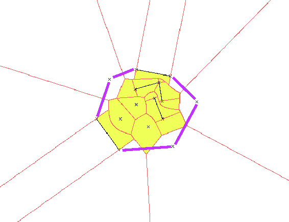
Figure 5: Convex hull of a figure (white: infinite cells)
3.2 Skeleton
The skeleton of a contour is the locus of points inside of it that are
minimally equidistant to it. With Voronoi, simply select edges within the
contour. This may be achieved quickly if the contour is oriented: select
BISECTOR, PARABOLA and DEGENERATE edges related to similarly oriented,
inside-indicating segments; select also MEDIATRIX edges associated to any
point site for which the inside angle (angle between the two connected
segments, measured in the inside of the contour) is larger than PI (or,
if points are oriented, MEDIATRIX edges associated to inside-indicating
points). This is a small O(n) algorithm.
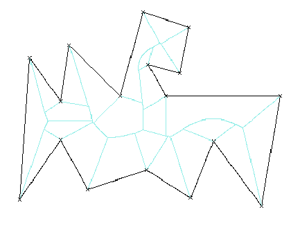
Figure 6: Skeleton
3.3 Centroid
A centroid is a point indicated inside a contour, providing some kind of
handle to the whole surface. For convex shapes, the centre of gravity is
often chosen as the representative centroid. For complex shapes however,
the centre of gravity may lie outside of the contour. With Voronoi, any
point of the skeleton is a sure centroid, and a refined one is the node
of it with the greatest dMax. Which makes a small O(n) algorithm.
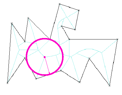
Figure 7: Centroid
3.4 Frontier
The frontier between two objects (two coasts, two banks etc.) may be defined
as the locus of points equidistant from the objects. Simply select interface
Voronoi edges.
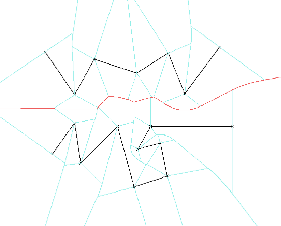
Figure 8: Frontier
3.5 Dilation
Dilation in morphological mathematics consists in making an external ball
with radius r roll on a contour, and in recording the trace of the
center of the ball.
With Voronoi, select external edges that support distance r,
and, by sites, points at distance r on them, and connect these points
by pair successively by a segment parallel to the segment site, when the
two edges relate to a same segment site, by an arc circle centred on the
point site when the two edges relate to a same point site (unless the two
points of the pair belong to a same edge, in which case there comes a fusion
of the inside). This makes a O(n) algorithm.
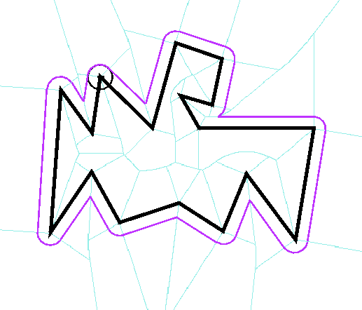
Figure 9: Dilation
3.6 Erosion
Erosion in morphological mathematics consists in making an internal ball
with radius r roll on a contour, and in recording the trace of the
center of the ball.
With Voronoi, select internal edges that support distance r,
and, by sites, points at distance r on them, and connect these points
by pair successively by a segment parallel to the segment site, when the
two edges relate to a same segment site, by an arc circle centred on the
point site when the two edges relate to a same point site (unless the two
points of the pair belong to a same edge, in which case there comes a rupture
of the inside, a discontinuity in the result). This makes a O(n) algorithm.
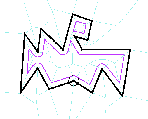
Figure 10: Erosion
3.7 Closure
Closure in morphological mathematics consists in eroding with radius
r2
a dilation with radius r1, with r2 < r1.
Let r' = r1 - r2. With Voronoi, select external
edges that support distance r1, and, by sites, points at distance
r1 on them. These are called "further points" in the following.
Project each further point on either of its sites. On each segment (further
point , either of its projection), calculate point P at distance
r2 from the further point. When the two sites of the projections
are not a segment and one of its end point, connect them by an arc circle
with radius r2 centred on the further point. Else, by site, connect
successive points P by a segment parallel to the segment site, when
the two projections relate to a same segment site, by an arc circle with
radius r' centred on the point site when the two projections relate
to a same point site (possible intersections & fusions of the resulting
contour may occur with this simplified version of the algorithm). This
is an O(n) algorithm.
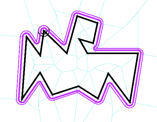
Figure 11: Closure
3.8 Opening
Opening in morphological mathematics consists in dilating with radius
r2
an erosion with radius r1, with r2 < r1.
Let r' = r1 - r2. With Voronoi, select internal
edges that support distance r1, and, by sites, points at distance
r1 on them. These are called "further points" in the following.
Project each further point on either of its sites. On each segment (further
point , either of its projection), calculate point P at distance
r2 from the further point. When the two sites of the projections
are not a segment and one of its end point, connect them by an arc circle
with radius r2 centred on the further point. Else, by site, connect
successive points P by a segment parallel to the segment site, when
the two projections relate to a same segment site, by an arc circle with
radius r' centred on the point site when the two projections relate
to a same point site (possible intersections & fusions of the resulting
contour may occur with this simplified version of the algorithm). This
is an O(n) algorithm.
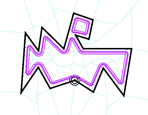
Figure 12: Opening
3.9 Hausdorff distance between lines
The Hausdorff distance between two lines A and B is the greater of the
two measures:
-
dHa>b: greatest of all smallest distances from the points
of A to B
-
dHb>a: greatest of all smallest distances from the points
of B to A
With Voronoi, only a finite set of distances needs investigation. For measure
dHa>b, compute the smallest distances to B from the vertices
of A and the intersections of A with the Voronoi diagram of B, and select
the greatest of all. (Alt et al. 1993) have shown this to be a O(
n . log n) algorithm.
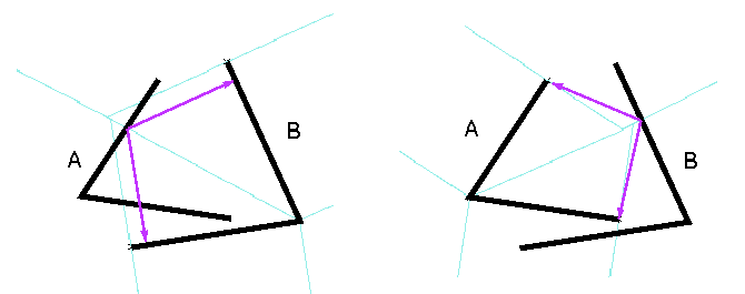
Figure 13: The two measures for the Hausdorff distance between lines,
from A to B, from B to A
3.10 Hausdorff distance between areas
The Hausdorff distance between two areas A and B is the greater of the
two measures:
-
dHa>b: greatest of all smallest distances from the points
of A to B
-
dHb>a: greatest of all smallest distances from the points
of B to A
With Voronoi, only a finite set of distances needs investigation. For measure
dHa>b, compute the smallest distances to B from 1/ the
vertices of A, 2/ the intersections of the contour of A with the Voronoi
diagram of the contour of B, 3/ the nodes of the external Voronoi diagram
of B within A; and select the greatest of all. This also is a O( n . log
n) algorithm.
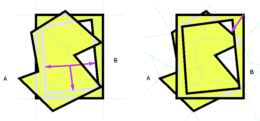
Figure 14: The two measures for the Hausdorff distance between areas,
from A to B, from B to A
3.11 Minimum Spanning Tree
The Minimum Spanning Tree of a set of elements is a non-cycling graph,
connecting all elements, the cumulated length of its segments being minimal
(compared to other non-cycling all-connecting graphs). Kruskal's algorithm,
as exposed in (O'Rourke 1995: p.189), consists in removing segments from
a broad set of candidate segments until the MST is constituted. With Voronoi,
the initial set of candidates is reduced to a small O(n), as demonstrated
in (Hangouët 1998: 160-2): select interface edges for which dMin
is different from both dNa and dNb, and use as candidate
segment the pair (the point site, its projection on the other point or
segment site).
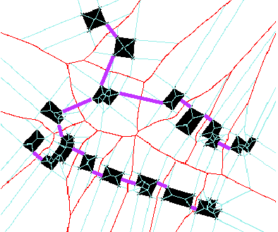
Figure 15: Minimum Spanning Tree on houses
3.12 Geometric waterlining
Waterlining may be defined, in cartography, as the ornemental representation
of sea or large rivers in land maps. In (slight) opposition to figurative
waterlining (e.g. horizontal lines, or suggestive flow lines, or fishes
and waves...), geometric waterlining is mechanically shore- (or
bank-) dependent: limicolous points and stretches are made to radiate concentric
circles and parallel lines into the water, until they meet other yet simultaneous
circles and lines. From the evidence found in some of the Institut Géographique
National's collections, it seems that geometric waterlining was in use
in French map-making for two hundred years from the mid eighteenth century
until after World War II (see e.g. the 1762 "Carte Géométrique
du Comté de Nice" and the 1944 edition of the thrichrome edition
of the "Nouvelle Carte de France"). In the nineteenth century, the technique
was spread worldwide. In his beautiful and important article (Christensen
1999), Christensen describes how waterlining may be revived thanks to the
computer, for ornemental drawing yet also for automated spatial analysis.
To draw such waterlines with Voronoi, you merely draw dilations of
the land into the water with increasing radii.
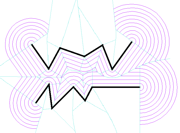
Figure 16: Geometric waterlining between two banks
Note: It is obvious that on vector data, where polylines make the geometry
of the objects, a continuous layering of waterlines and a segment Voronoi
diagram are equivalent. The "lack of normalization" for which Christensen
reproaches Voronoi diagrams (Christensen 1999: 35) in his otherwise precise
and indeed visionary article, if I interpret it correctly, actually addresses
the approximation of line data by point data: what in Christensen's paragraph
is true of Voronoi diagrams on points (while data come as lines), no longer
holds for Voronoi diagrams on segments as exposed in the present paper.
3.13 Bouligand-Minkowski fractal dimension
The Bouligand-Minkowski fractal dimension of a line C is the limit
of the expression, when r tends toward 0:
2 - ln A(r) / ln
r ,
where A(r) is the area of the "Minkowski sausage" around line C,
i.e. line C dilated on its both sides with a radius r.
This on vector data requires intensive computing, which Voronoi somewhat
alleviates: for each of the chosen r, the dilation on both sides
of the line is computed, then the area of the result. This makes a succession
of O(n) computations.
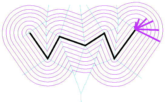
Figure 17: Minkowski sausages of different widths
Note: How to bypass the computation of the area, using the ratio: ln
N(r)
/ ln r, with N(r) number of Voronoi edges with dMin
< r , is currently being studied.
3.14 Yet another query...
It seems that away from the big cities - not only from Paris, but also
from Amsterdam, Rotterdam and so many others across Europe - one can live
better and happier to the world, than in their vicinity... (van Gogh
1889: 532)
In a world where over five sixths of the people are scoundrels,
fools or idiots, the rest are forced to live apart, all the more so when
they are different - and the greater the distance, the better... (Schopenhauer
1830: 27-8)
Voronoi will help geniuses find isolation: simply select the interface
node with the greatest distance to the crowded places...
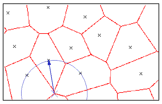
Figure 18: A happier place
Conclusion
It is well-known that topology (possibly explicitly stored, at least in
the awareness we have of it) makes programming spatial queries both more
intuitive and more efficacious. The same holds for Voronoi diagrams, and
beyond the practical descriptions provided in this paper (which after all
may or may not be programmed as such) lies the epistemological argument
that the knowledge at least of the properties of Voronoi diagrams on segments,
provides one (not omnipotent but in the cartometric domain, reliable) context
or paradigm both for apprehending vector geographic data and for programming
spatial queries.
References
Alt, H., Behrends, B. and Blömer, J. 1993. Approximate Matching
of Polygonal Shapes. Institut für Informatik, Freie Universität
Berlin, Report B 93-10, July 1993, available from here
Boissonnat, J.D. and Yvinec, M. 1995. Géométrie algorithmique.
Paris: Ediscience international
Christensen, A. 1999. The Revival of a Victorian Art: Waterlining
with a Computer. The Cartographic Journal, vol.36 No.1 pp.31-41, June
1999
Computational
Geometry Resources
Gold, C. 1999.The Voronoi Web Site
Hangouët, J.F. 1998. Approche et méthodes pour l'automatisation
de la généralisation cartographique ; application en bord
de ville. Thèse de doctorat, Université de Marne-la-Vallée
Okabe, A. Boots B. and Sugihara K. 1992. Spatial Tessellations. Concepts
and Applications of Voronoi Diagrams. Chichester: J. Wiley and sons
Open GIS Consortium. 1999. The OpenGISTM Abstract Specification.
Topic 1: Feature Geometry (version 4). OpenGISTM Project
Document Number 99-101.doc
O'Rourke, J. 1995. Computational Geometry in C. Cambridge University
Press.
Prisme project
Schopenhauer, A. ca. 1830. Eis Eauton. Paris: Anabase 1992. Translated
from the German by Guy Fillion (passage translated from the French by the
author)
Strabo. ca. 7bc. Geography, Books 1-2. Translated by Horace Leonard
Jones. Cambridge (Ma), London: Harvard, Loeb Classical Library. LCL 49
van Gogh, V. 1889. Letter #598F (to his mother, June 1889) in
Correspondance Générale vol.III, Paris: Gallimard, 1990,
(passage translated from the French by the author)