Return to GeoComputation 99 Index
Scott Rice-Snow
Department of Geology, Ball State Univ., Muncie, IN 47306 U.S.A.
E-Mail: ricesnow@wp.bsu.edu
Joshua Russell
Rocky Mountain Consultants, 825 Delaware Ave. Suite 500, Longmont, CO 80501 U.S.A.
We have collected a variety of elevation and relief values for 336 points (measurement stations) spaced at 10 km linear intervals along the U.S. Continental Divide extending from Mexican to Canadian border. The information was derived from 1:100,000 topographic quadrangles, with vertical resolution on the order of map contour intervals (20-50 m). These compiled measures can be treated as sequential data sets and tested for self-affine characteristics by rescaled range (R/S) analysis. Results show a good fit to the self-affine model for all measures tested, with sample intervals of 5 to 336 stations.
Elevation data series for the Continental Divide crest yield very uniform, low D values in the approximate range 1.02-1.04. This indicates a very high degree of persistence in values, with consistent self-affine character bridging the scales of mountain range segments, entire ranges, and full physiographic provinces. Among the measures there is slightly higher persistence for minimum Divide elevation within 5 km radius of station, than for station point elevation or maximum Divide elevation within 5 km.
Various local relief statistics also show significant long-range persistence along the Divide, although with D values consistently higher than obtained for elevation series. Among the statistics, relatively low fractal dimension values (approx. 1.05) indicate very high along-divide persistence for overall relief measures, including relief from Divide station to lowest point within 10 km radius, and maximum relief available within 5 km. The least persistence (D range 1.12-1.18) is indicated for more subtle relief along the Divide crest within 5 km of station, and relief in the immediate vicinity of the Divide, from station to lowest point within 1 km radius.
Unlike Continental Divide elevation series and associated overall relief measures, the more subtle Divide relief statistics, with their reduced degree of long-range persistence, show little systematic variation from one physiographic province to another. These divide- crest and very local divide-area relief characteristics are largely independent of regional geologic controls.
This study is an extension of earlier and continuing work on the map-view irregularity of drainage basin boundaries (Breyer and Snow, 1992; Rice-Snow, in press), and of the North American Continental Divide in particular (Rice-Snow, 1995, 1997). Drainage divides are self-similar in map view, showing instances of both homogeneous and inhomogeneous fractal character. The Continental Divide within the borders of the conterminous United States is a prime example for the study of drainage divide geometry because of the large range of scales available for study, even if limited to standard map data sources, and because the Divide traverses a variety of lithologic, structural, and climatic zones. Much of the gross structural variability, and significant but lesser portions of the lithologic and climatic variability, is represented by six major physiographic provinces (Fenneman, 1928) crossed by the Divide. These include, from south to north, the Basin and Range, Colorado Plateau, Southern Rocky Mountains, Wyoming Basin, Middle Rocky Mountains, and Northern Rocky Mountains provinces.
Topographic elevation data sets have been widely interpreted as self-affine fractals (Turcotte, 1992; Snow and Mayer,1992). With a wish to examine vertical aspects of irregularity along the Divide, we have collected elevation and relief data for a series of points and associated radial areas, in equally-spaced (linear) steps along the divide crest. These points are arrayed in sequence along a curve with complex, self-similar character, unlike linear topographic profiles and areal digital elevation models studied previously by others. However, it is still reasonable to treat the information as a group of one- dimensional, naturally sequential data sets. We had particular interest in exploring any cross-scale persistence of elevation and relief characteristics along the Divide.
The rescaled range method, or R/S analysis (Mandelbrot and Wallis, 1969; Mandelbrot, 1983; Feder, 1988), has been applied to test self-affine character and persistence features of a wide variety of geophysical data. Typical applications have been to time series (Mandelbrot and Wallis, 1969; Feder, 1988), and stratigraphic analog time series (Fluegeman and Snow, 1989; Wang, et al., 1992). Applications in an overt spatial analysis context are not unknown: a group of studies (Hewett, 1986; Emanuel, et al., 1989) investigate scaling behavior of porosity fluctuations in petroleum reservoir rocks via R/S analysis. In the present study we apply R/S analysis to the sequential elevation and relief data sets, another example of the method's utility in testing long-range persistence of spatial data.
We collected elevation and relief values for 336 stations along the U.S. Continental Divide extending from the Mexican to the Canadian border. Stations were established by manually walking map dividers with 10 km spacing along the irregular Divide trace, as mapped by the U.S. Geological Survey on 1:100,000 scale topographic quadrangles. Stations were selected as points on the Divide crest, nearest to last station along the trace in case of multiple intersections with the divider arc, on the 10 km intervals.
Elevation measures recorded for the Continental Divide were station point elevation as well as maximum and minimum Divide crest elevations within 5 km radius of station. The latter two measures comprise a non-overlapping sampling of Divide elevation extremes for most (but not the entirety) of the Divide trace. Relief values of various types were also recorded:
One might question the basis for a practical distinction between maximum elevation encountered within some radius, and maximum elevation on the divide alone, within the same radius, as independent relief statistics. Does a difference in the two maximum elevation measures occur in a significant number of cases, or are the contrasts between general relief and divide relief values, as defined above, effectively the result of differences in the relevant elevation minima alone? Survey of the collected data for this study indicates that the maximum elevation value within 5 km radius occurs elsewhere than the Divide for more than ten per cent of stations, making it a significant, though lesser, component of difference between the relief values.
By and large, we took elevation values for all measures from the nearest mapped contour lines (20 to 50 m contour intervals) or from mapped point elevations, rather that attempting to interpolate or extrapolate point elevations between contours. Such attempts to obtain better quality of elevation and relief data would have limited value, in light of the possible error in absolute elevation values, on the order of contour interval, specified for the quadrangles.
Elevation and relief values obtained for the Continental Divide are shown in Figure 1. The
series of topographic and relief profiles show notable variation in degree of qualitative
distinction among the sections within different physiographic provinces. The elevation
series show distinct shifts in mean value associated with the different provinces, with
province boundaries distinctly marked. Gross, or broad-area relief measures such as
general relief and 10-km-radius point relief retain strong mean value distinctions between
mountainous provinces and lowland/plateau provinces. For the subtle, or limited-area,
relief measures such as 1-km-radius point relief and divide relief, mean value distinctions
among physiographic provinces are subtle to lacking, and while textural variations for the
series retain more distinct character among provinces, the province boundaries are not so
well marked. In comparison to the elevation and gross relief measures, it is reasonable to
conclude that these subtle Divide relief statistics show little systematic variation from one
physiographic province to another, being largely unaffected by the associated geologic
controls on topography.
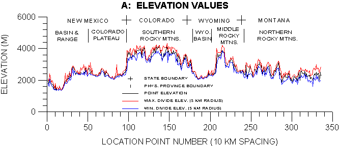
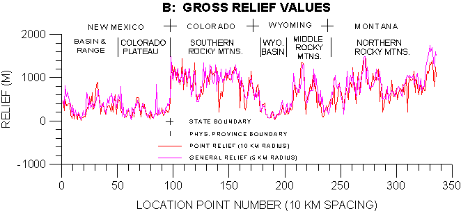
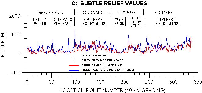
Figure 1. Plots of elevation and relief data series for 336 stations along the Continental Divide in the conterminous United States. (A) Elevations on the Divide crest. (B) Relief values for relatively large areas associated with the Divide. (C) Relief values focusing on the immediate vicinity of the Divide, and on the Divide crest alone.
Rescaled range analysis of the sequential data sets resulted in plots of mean R/S value over the full range of available non-overlapping data intervals. The value R is a cumulative data range statistic, and S is the source data standard deviation (Mandelbrot, 1983; Feder, 1988). The graphs are similar to the 'pox diagrams' of Mandelbrot and Wallis (1969), however lacking the scatter of individual R/S values contributing to the mean. Linearity in these logarithmic plots indicates self-affine character, and a plot slope (H) greater than 0.5 indicates persistence of values, in the source data: the combination of these two characteristics for large data intervals is termed long-range persistence. The fractal dimension (D = 2-H for H > 0.5) indicates increasing degrees of persistence as it approaches 1.0, thus departing further from the D value of 1.5 for a random signal.
Plots for elevation data series are shown in Figure 2; those for relief series, in Figure 3. The results uniformly show a good fit to the self-affine model, with high degrees of persistence (D = 1.0-1.2) extending to the longest spatial intervals tested. The plots display strong linearity for sample intervals of 5 to 336 stations. For the smallest intervals available (3-5 stations) there is a divergence from the trend to somewhat lower plot slope. We have chosen to omit these points (with an additional margin: up to 7 stations) from the linear regressions to obtain overall plot slopes and corresponding D values.
It is possible that the small-interval deviations represent actual scale heterogeneities in the data, but there is precedent as well to consider them artifacts of the analysis method. Mandelbrot and Wallis (1969) note 'initial transient' deviations to higher plot slope, occurring at small data intervals in pox diagrams for a number of their example temporal records, and indicate that they are statistical artifacts. However, the transients displayed in their plots are opposite in sense to the deviations in the present study. In our analyses of the Continental Divide data sets, some cases with S equal to zero were typically removed from the R/S averaging for data intervals of three and four, again bringing the reliability of these values into question.
Nevertheless, these plots from rescaled range analysis represent exceptionally clear demonstrations of self-affine character and long-range persistence. By way of comparison, a variogram derived from the station point elevation series maintains clearly linear form for the range of one to about fifteen data intervals, deviating to negative slope beyond 80 intervals, a form feature typical of topographic variograms. The fit to the linear portion of the variogram suggests a H value of 0.34 and D value of 1.66, highlighting the qualitative difference in data characteristics addressed by the two methods.
The three elevation data series for the Continental Divide crest yield very uniform, low, D values in the approximate range 1.02-1.04 (Fig. 2). This indicates a very high degree of persistence in values. The linearity of the plots indicates a consistent self-affine character, with the same degrees of persistence in elevation values bridging the scales of mountain range segments, entire ranges, full physiographic provinces, and the Continental Divide segment as a whole. There is a slightly higher persistence (D = 1.02, Fig. 2C) demonstrated for minimum Divide elevation within 5 km radius of station, than for point elevation or maximum Divide elevation, both of which can be interpreted to have slightly higher components of randomness in sequential values.
The diverse relief statistics show much more variability in fractal dimension value, although never departing from strongly persistent character. Rescaled range analysis (Fig. 3) again highlights a contrast between the measures of gross and subtle relief. The gross measures, general relief (5 km radius) and point relief (10 km radius), show very high along-divide persistence (Fig. 3A, 3B), with D values of 1.07 and 1.045 approaching, but greater than, those for the elevation series.
The subtle measures show the least persistence (D range 1.12-1.18). Point relief (1 km
radius) yields D value of 1.125 (Fig. 3C), although it relates to features intermediate in
range of coverage from the Divide trace, compared to the gross relief measures and the
crest elevation values. The highest value of fractal dimension (1.18) and lowest degree of
persistence is associated with the relief between high and low points on the Divide crest
(5 km radius), as shown in Figure 3D. The relief on the Divide ridge itself is the measure
least characterized by short and long-range correlations of values.
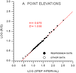
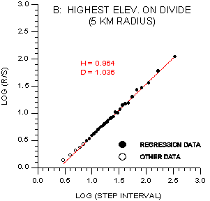
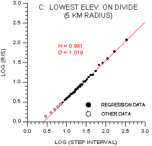
Figure 2. Rescaled range (R/S) analysis results for elevation data series along the
Continental Divide. The value H is the slope of the plotted linear regression line.

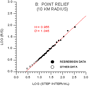
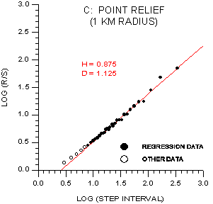
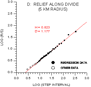
Figure 3. Rescaled range (R/S) analysis results for relief data series along the Continental Divide. (A, B) Relief values for relatively large areas associated with the Divide. (C, D) Relief values focusing on the immediate vicinity of the Divide, and on the Divide crest alone.
Among the relief measures tested, a very localized relief value, the point relief (1 km radius), and a measure of local (5 km radius) variation in the elevation of the Divide crest are marked by significantly higher D values (1.12-1.18), indicating relatively low degrees of persistence. These subtle relief values are the same ones whose plotted series (Fig. 1C) lack clear signatures of the six different physiographic provinces traversed by the Divide. While all data series tested fall within the strongly persistent range of self-affine fractal dimensions, well below the value of 1.5 for random records, the range of D values (1.0-1.2) nevertheless encompasses records that can clearly mark or almost completely obscure long-range trends, with strong contrasts in the degree to which effects of geologic structure and other regional controls are apparent in topographic measures.
Breyer, S.P., and Snow, R.S. (1992) Drainage basin perimeters: A fractal significance: In R. S. Snow and L. Mayer, eds., special issue on "Fractals in Geomorphology", Geomorphology, v. 5, p. 143-157.
Emanuel, A.S., Alameda, G.K., Behrens, R.A., and Hewett, T.A. (1989) Reservoir performance prediction methods based on fractal geostatistics: SPE Reservoir Engineering, v. 4, n. 3, p. 311-318.
Feder, J. (1988) Fractals: New York, Plenum Press, 283 p.
Fenneman, N.M. (1928) Physiographic divisions of the United States: Annals of Association of American Geographers, v. 18, p. 261-353.
Fluegeman, R.H., and Snow, R.S. (1989) Fractal analysis of long-range paleoclimatic data: Oxygen isotope record of Pacific core V28-239: Pure Appl. Geophys., v. 131, p. 307-313.
Hewett, T.A. (1986) Fractal distributions of reservoir heterogeneity and their influence on fluid transport: 61st Annual SPE Tech. Conf. (New Orleans), Paper SPE 15386.
Mandelbrot, B.B. (1983) The Fractal Geometry of Nature: Freeman and Co., New York, 468 p.
Mandelbrot, B.B., and Wallis, J.R. (1969) Some long-run properties of geophysical records: Water Resources Research, v. 5, p. 321-340.
Rice-Snow, S. [in press] Fractal characteristics of drainage basin boundaries in Puerto Rico: Proceedings of the International Symposium in Hydrology in the Humid Tropic Environment (International Assoc. of Hydrological Sciences).
Rice-Snow, S. (1997) Fractal geometric characteristics of the North American Continental Divide, Abstracts of American Association for the Advancement of Science (AAAS) Annual Meeting, Seattle, Washington, p. 97.
Rice-Snow, S. (1995) Geometry of the Continental Divide, Geological Society of America Abstracts with Programs, v. 27, n. 6, p. 57.
Snow, R.S., and Mayer, L. (editors, 1992) Fractals in Geomorphology: special issue, Geomorphology, v. 5, n. 1/2, p. 1-194.
Turcotte, D.L. (1992) Fractals and Chaos in Geology and Geophysics: Cambridge University Press, Cambridge, 221 p.
Wang, Y., Evans, M.E., and Xu, T.C. (1992) Rescaled range analysis of paleoclimatic proxies: Canadian Journal of Earth Sciences, v. 29, p. 296-300.