Paulo H. Afonso, Mário R. Gomes and M. Graça Abrantes
INESC - Instituto de Engenharia de Sistemas e Computadores, R. Alves Redol 9 - 6º, 1000 Lisboa, Portugal
Email: pha@inesc.pt, mrg@inesc.pt, graca@isa.utl.pt
This paper presents a specification and prototype of a Geomarketing Decision Support System based on Fuzzy Set Theory. This system provides marketers with a support for the decision-making process, coupling with a set of geomarketing problems, to satisfy marketers' needs of efficient geographical information analysis.
This system has the advantage of handling imprecise data. In fact, some of the biggest difficulties in the application of GIS in business come from lack of exactness of data about markets. On the other hand, since information with the required precision for statistical modelling is rarely obtained, an alternative for this type of modelling is needed. To overcome these difficulties, the system uses Fuzzy Data and Fuzzy Modelling. Fuzziness occurs when an object or a fact cannot be defined precisely. Fuzzy Set Theory is an appropriate means of modelling imprecision or vagueness. In addition, an expert doing spatial analysis may prefer to work in imprecise terms, closely to the way he deals with problems. Among other advantages over classical models, such as statistic models, fuzzy models are easier to understand, build, and modify. Finally, the integration of imprecise data models with visualisation tools is considered a pre-requisite for the effective implementation of decision support systems.
The field of Marketing is concerned with bringing products to customers in the context of a market, with existing dealers and competitors. Marketing instruments can be classified as product, price, promotion and geography [4].
The demand and offer of a product are easily related with geographical locations. In fact, some sources state that about 90% of business information are geographical [8]. Therefore, marketers need to analyse efficiently geographical information in order to gain competitive advantage and effectiveness in business.
Geomarketing copes with this kind of information, by using geographical criteria to optimise commercial actions. As examples of analysis, we have evaluation of business potential of a region, for a product; market segmentation; sales territory definition.
Geographical Information Systems are powerful tools for these types of analyses, since they provide a platform that enables the representation of existing spatial relations between market components (clients, selling and competitors). Furthermore, graphical visualisation of analysis results enhances their understanding [3].
This paper presents a specification of a prototype for a Geomarketing Decision Support System based on a Fuzzy Expert System. This system provides marketers with a support for the decision-making process, coupling with a set of geomarketing problems, to satisfy marketers' needs of efficient geographical information analysis. To illustrate this system, we present an application in the area of Tourism Marketing. This prototype is currently being developed.
This section describes the technologies used to develop the system; namely Marketing Decision Support Systems integrated with GIS and Fuzzy Expert Systems.
According to [4], a Marketing Decision Support System (MDSS) is a set of decision models with supporting hardware and software available to marketing managers to assist them in analysing relevant business data and making better marketing decisions. Because there is a growth of the amount of information that managers get during decision processes, models are useful to relate information with decision needs [5]. Furthermore, models allow the creation of scenarios. In our system, the modelling component is implemented by an Expert System.
MDSSs can be linked to a GIS, to constitute Geomarketing Decision Support Systems (GDSS), which can analyse geographical information, by including in the models, the spatial component.
An Expert System (ES) is defined by the Expert Systems group of the British Computer Society as: 'the modelling, within a computer, of expert knowledge in a given domain, such that the resulting system can offer intelligent advice or take intelligent decisions' [10].
The most important modules that constitute a rule-based expert system are the knowledge base, the inference engine and the explanation subsystem [7].
The knowledge base contains if-then rules, which represent knowledge of a particular domain, and facts about a specific problem to be solved by the expert system.
The inference engine applies existing knowledge in the knowledge base, in order to find a solution of actual problems. To do so, it uses a data-driven or a goal-driven reasoning process. In data-driven reasoning, the inference engine begins with the given facts of the problem, and fire rules until the solution to the problem is found. Alternatively, in goal-driven reasoning, the solution of the problem is known, and the inference engine tries to find what facts lead to that solution. In our case, the ES has a data-driven reasoning process, since the decision process starts with facts, and conclusions are needed to arrive at a decision.
After a problem is solved, the explanation subsystem provides to the user an explanation of the reasoning, answering questions like how or why a result is given.
In the field of marketing management, ESs are useful to improve the quality of managers' decisions, in a number of important functions, such as:
Because some of the biggest difficulties in the application of GIS in business come from lack of exactness of data about markets, we are using a special case of ES, which is a Fuzzy ES.
Fuzziness occurs when an object or a fact cannot be defined precisely. In order to model this imprecision, or vagueness, Fuzzy Set Theory can be used. This theory represents gradients of certainty, which enables its inclusion in models of uncertainty [2]. In our system, the qualification of quantitative data about markets is done with this theory.
According to [14], fuzzy modelling has the following advantages: these models maintain concept's imprecise nature, by using linguistic variables; the formulation of hypothesis in natural language results in the elimination of the need of mathematical and statistics assumptions and simplifies the model building and specification process.
In [12], the following advantages of this type of modelling are pointed out: by using the conventional approach, the value associated to a given feature is expressed in one single value, while fuzzy modelling reflects the fact that preferences and opinions are difficult to reduce to a single value. In addition, an expert doing spatial analysis may work in imprecise terms, closely to the way he deals with problems.
Finally, information with the required precision for statistical modelling is rarely obtained [2].
This section presents an application example, in which decision support is needed to solve a Site Location problem, in Tourism Marketing, based on the geographical criteria presented on [10].
When a tourism company wants to set up a new tourist resource and has to choose a site, among a set of alternative sites, these have to be evaluated, and the one with the best evaluation is chosen. This is done to improve tourist development, which increases both overall viability and the quality of the tourist's experience.
The DSS provides support to this decision, by combining, for each alternative, both geographical data and knowledge of the domain. The evaluation process is described below.
For each alternative site, a set of geographical characteristics is evaluated, with the use of spatial operators like nearest, buffer, euclidean distance and network distance. The geographical characteristics to be evaluated can be tourist resources; infrastructures and facilities; transport links; industrial units; competitors; localities.
The nearest operator is used, for example, to identify the nearest competitor to a site1, and the euclidean distance operator can give the distance between these two elements. The buffer operator is useful to identify, for example, the existing tourist resources, within a distance from the location. The distance in a network is used, from example, to characterise the quality of transport links to site, average distance from site to locality or average distance from competitors to locality.
The values resulting from evaluating geographical characteristics, together with information regarding business, economics, climatic conditions, etc. are given as inputs to a model, defined in the knowledge base of the fuzzy ES. The rules in the knowledge base are typically of this form:
If DistanceToCompetitors is HIGH
![]() and DistanceToPopulation is LOW
and DistanceToPopulation is LOW
![]() and AdjacentTouristAtraction is HIGH
and AdjacentTouristAtraction is HIGH
![]() and RegionEconomicSituation is GOOD
and RegionEconomicSituation is GOOD
![]() then SiteAttractiveness is HIGH
then SiteAttractiveness is HIGH
In this example, the values of Dist. and Adjac. would be numeric values given from spatial operators. The RegionEconomicSituation would be a fuzzy value, given by the economics information of the region. The LOW, HIGH and GOOD values can be defined by means of fuzzy sets. This way, the uncertainty about the differences between a high, medium and low distance, and bad, medium and good economical situation are modelled.
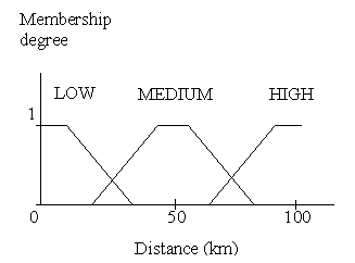
For example, the membership functions for the fuzzy sets LOW, MEDIUM and HIGH, for the DistanceToCompetitors variable are defined in the following figure:
The result of firing a set of rules for a given alternative location is a value, which can be interpreted as a measure of the location's tourist potential. Finally, the selected alternative is the one with a highest tourist potential.
The analysis and design of a prototype for this DSS is presented next. To specify the prototype, the GeoOMT (Geographical Object Modelling Technique) was used. GeoOMT is defined in [1]. This method is an extension of the OMT, which is presented in [13]. These methods are based in object oriented techniques.
In the analysis section, the requirements of the system are enumerated, and the object and functional models are described. In the design section, the architecture of the system is presented, and the chosen software is referred to.
In this first step of OMT, the system is modelled, by stating what must be done, without restricting how and when it will be done. To do so, first the requirements of the system are stated. Next, a model of the system is built, composed of object models, dynamic models and functional models.
The object model describes the static structure of the system, in terms of objects. The dynamic model describes the state transitions of the system, and the functional model describes data transformations. Since our system is very static, the dynamic model is not important to this specification.
The activities and operations to be supported by the system are:
The object model shows the static structure of the system, describing classes of objects and its relations, and organises the structure in parts:
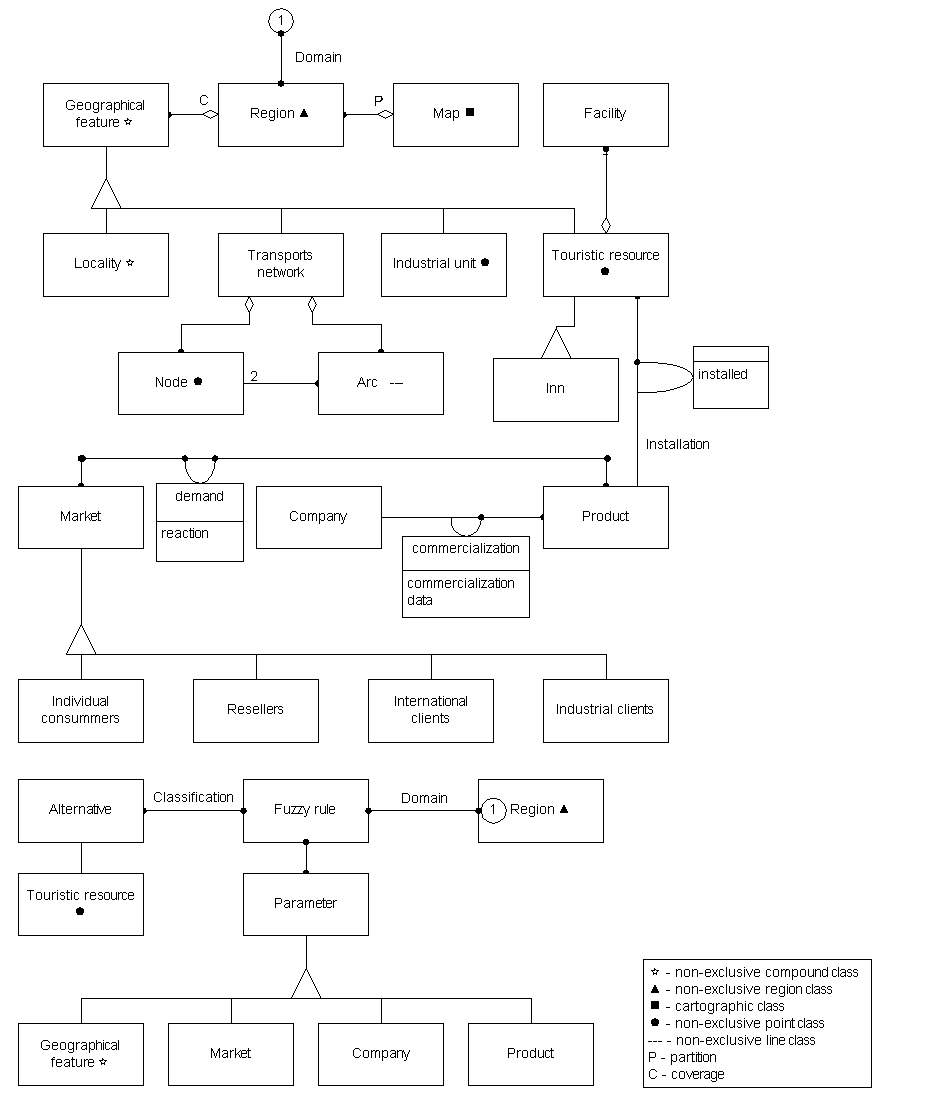
In this object model, the inn object class is given as an example of a tourist resource. The model can be enriched with object classes like museum, beach, etc.
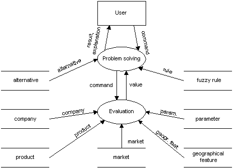
This model shows how output values are derived from input values, without stating the order by which they are calculated. A functional model consists of a set of data flow diagrams, showing the functional relations of the computed values, including inputs, outputs and stored values. These diagrams consist of processes, which transform data; data flows, which move data; data stores, to store data passively; actor objects, which produce and consume data. Following is the most important conceptual data flow diagram of this model:
In order to build a solution to the problem, it is necessary to define a high-level strategy, which corresponds to the design of the system. The main decisions made in design concern the organisation of the system in sub-systems and the allocation of these to components of hardware and software.
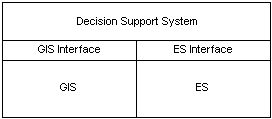
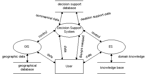
The system to implement consists of three main components, the DSS, the GIS and the ES. The DSS is a client of the GIS and the ES. To interface these three components, there are the GISI and ESI layers. This way, the system is modular, in which it is possible to replace both the GIS and the ES for some other systems, without changing the DSS. To do so, it is only necessary to write new interfaces, maintaining the functionality of the previous ones. The following picture shows how these five software layers are organised:
The picture below illustrates the main data flows that exist between the three systems and the user:
The hardware consists of a Pentium 200 MHz PC, running Windows NT. Given the system requirements, the chosen software are ArcView with Network Analyst, and JFS, a fuzzy expert system shell.
During the process of selecting a GIS, the considered alternatives were AutoCAD Map and Autodesk World. Additionally, MapObjects, a set of software components, was also evaluated. ArcView with Network Analyst had better results when evaluated, mainly because they provide a better set of spatial analysis functions, and have a better interaction with the user.
During the analysis and design phases of the prototype, the GeoOMT and OMT proved to be very useful, giving important guidelines on how to model the system.
Also, fuzzy modeling proved to be a very simple way to combine a set of criteria, both geographical and non-geographical, by using linguistic terms, without the need of mathematical formulas. The imprecise nature involved in the qualification of a big distance or a good economic situation is represented with fuzzy sets, allowing the maintenance of concept's imprecise nature.
The authors would like to acknowledge the support provided by Dr. Paulo Rita. The contribution of the Oeiras Municipality was also important, by providing geographical data about that region.
This research is funded by PRAXIS XXI and JNICT through the fellowship PRAXIS XXI/BM/12916/97.
[1] Abrantes M G, 1998, Contribuições para uma metodologia de desenvolvimento de Sistemas de Informação Georgáfica (Contributions to a development methodology for GIS) PhD Thesis, Universidade Técnica de Lisboa, Instituto Superior Técnico
[2] Davis T J, Keller C P, 1997, Modelling uncertainty in natural resource analysis using fuzzy sets and Monte Carlo simulation: slope stability prediction, in International Journal of Geographical Information Systems, Vol. 11, Nº 5, pp. 409-434, Taylor & Francis
[3] Jarvenpaa S L, Dickson G W, 1988, Graphics and managerial decision making: research guidelines, in Communications of the ACM 31(6)
[4] Kotler P, 1991, Marketing Management - Analysis, Planning, Implementation and Control, Prentice Hall
[5] Lilien G L, Kotler P, Moorthy K S Marketing Models, Prentice Hall, 1992
[6] Little J D C, 1979, Decision Support Systems for Marketing, in Managers Journal of Marketing 43(3)
[7] Luger G F, Stubblefield W A, 1989, Artificial Intelligence and the Design of Expert Systems, Benjamin/Cummings
[8] Moloney T, Lea A C, Kowalchuk C, 1993, Manufacturing and packaged goods, in Profiting from a Geographical Information System, GIS World Books Inc, Fort Collins
[9] Moutinho L, Curry B, Davies F and Rita P, 1994, Computer Modeling and Expert Systems in Marketing, Routledge, London and New York
[10] Moutinho L, Rita P and Curry B, 1996, Expert systems in tourism marketing, Routledge, London and New York
[11] Rathmell J M, 1974, Marketing in the Service Sector, Whinthrop Publishers Inc., Cambridge, Mass
[12] Rimsha S, Wolf W, January 1997, Modelling in an uncertain World, in GIS Europe, pp. 18-20, Adams Business Media
[13] Rumbaugh J, Blaha M, Premerlani W, Eddy F, Lorensen W, 1991, Object-oriented Modeling and Design, Engelwood Cliffs, NJ: Prentice Hall
[14] See L, Openshaw S, 1997, An Introduction to the fuzzy logic modeling of spatial interaction, in Third JEC - Proceedings, pp. 809-918, IOS Press